Showing posts with label Video. Show all posts
Showing posts with label Video. Show all posts
Wednesday, November 18, 2015
Stark Street - A Rough Draft
Recreating the Historic Columbia River Highway: Stark Street - A Rough Draft from A. F. Litt on Vimeo.
A rough look at the early Stark Street route of the Columbia River Highway from Milepost Zero at Washington and Broadway in Portland to the Stark Street Bridge on the Sandy River...
Music:
"Junction" by Kai Engel
freemusicarchive.org/music/Kai_Engel/Paradigm_Lost/09_-_Junction
Licensed under a Attribution-NonCommercial-ShareAlike License.
creativecommons.org/licenses/by-nc-sa/4.0/

Tuesday, November 17, 2015
Troutdale: Dead Sheep Goo Pit
Yep...
Eastwinds Development will be building a new hotel and community complex on the site of the old Bissinger Wool Pullery.
The company is voluntarily removing the remains of thousands of dead sheep buried alongside the iconic water tower from the 1930s.
The pit where Bissinger buried the dead sheep is now covered in dirt and blackberry bushes. Tests revealed that just below the surface of dirt and blackberry bushes, the pit of dead sheep has turned into a kind of goo.
Sheep goo removal to cause big stink in Troutdale
http://www.katu.com/news/local/Dead-sheep-goo-removal-Troutdale-Bissinger-Wool-Pullery-to-cause-big-stink-in-Troutdale-350569311.html
Monday, November 16, 2015
Timelapse: Multnomah Falls to Dodson
The original idea behind this project was to create a timelapse video of the original Route 2 route through the Gorge... While it has grown a long way from that initial idea, it is still something I am working on.
Of course, my eyes blur after watching a timelapse video for more than a minute or so, which is one of the reasons this project grew into a full documentary. To combat that, I am breaking the timelapse into one minute sections, aligned with the sections on the website.
These are a little rough, but they are what they are. I don't want to take the time to really clean them up at this point, I have more interesting films to make about the highway now!
Monday, September 21, 2015
A short break on the videos
You might have noticed that I am taking a little break from video on this project. This is partially because I have been focusing on some research and photo editing and I have only so many hours in the day, and partially because I want to take a look at what direction I want the "web series" to take from here... Short pretty videos that are posted every week or so or a little longer documentary style shorts that come out every two to three weeks?
Surely it won't be all of one or the other, but I am in the process of figuring out which direction I want to go with the video content from here, and there are many factors involved.
I am also taking this time to clear some other jobs that are not related to this project, so I will be able to focus more time on it later this fall and winter.
Thanks to everyone for your support, it means a ton. This is a labor of love for me, but it is amazing and tremendously helpful to have so much support from everyone as I work on this project.
And to be clear, this is not an idle period... Look for a lot of new content appearing on the website over the next few weeks!
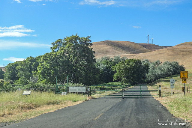
Gated (2013)
Maryhill Loops Road, Washington. May 21, 2013.
Wednesday, August 26, 2015
The Smokiest Day Ever?
Darryl Lloyd sent us this NASA photo of the smoke in the Pacific Northwest on Saturday, Aug. 22, which Darryl described as the smokiest day he's ever seen in the Columbia River Gorge.
Posted by Friends of the Columbia Gorge on Tuesday, August 25, 2015
Here's where the smoke is coming from. Do not call 911 unless you see a fire or something resembling a smoke column.
Posted by KATU News on Saturday, August 22, 2015

Smoke... http://
NASA photo of smoke over the Pacific Northwest at 2:10pm yesterday.
Posted by William Herold on Thursday, August 20, 2015
Wednesday, August 12, 2015
Oregon Experience’s documentary “The River They Saw”
A look at the early photographers of the Columbia River Gorge:
Friday, August 7, 2015
Friday, July 17, 2015
New Vimeo Channel!
Started a Vimeo channel for the project. I'll be posting my videos there eventually, but for now I am adding some neat ones from around Vimeo that I've found.
Oregon's Historic Columbia River Highway from Ian Langenhuysen on Vimeo.
Unfortunately, due to throttling issues on my currently free account, it might be awhile before I can get my videos up there, but I will get them up as soon as I can.
CLICK HERE to check out the new channel: https://vimeo.com/channels/recreatingthehcrh
Oregon's Historic Columbia River Highway from Ian Langenhuysen on Vimeo.
Unfortunately, due to throttling issues on my currently free account, it might be awhile before I can get my videos up there, but I will get them up as soon as I can.
CLICK HERE to check out the new channel: https://vimeo.com/channels/recreatingthehcrh
Tuesday, July 7, 2015
Monday, June 22, 2015
Monday, March 31, 2014
Peg Willis on A.M. Northwest
MEET THE AUTHOR
BOOK LAUNCH - Saturday, April 5 at 2 p.m. @ Hood County River Museum, sponsored by Waucoma Books (300 E Port Marina Dr, Hood River, OR)
Thursday, April 10 at 7 p.m. @ Pendleton Public Library, sponsored by Armchair Books (502 SW Dorion Ave, Pendleton, OR)
Saturday, April 12 @ Friends of Vista House Annual Training (Corbett, OR)
Saturday, June 14 from 6 a.m. to 4 p.m. @ 8th Annual Gorge Ride, sponsored by Friends of the Historic Columbia River Highway (The Dalles, OR)
Wednesday, June 25 at 7 p.m. @ Powells - downtown (1005 W. Burnside St., Portland, OR)
Thursday, August 7 at 7 p.m. @ The Clark County Historical Museum (1511 Main St, Vancouver, WA)
http://www.katu.com/amnw/segments/Buliding-the-Columbia-River-Highway-253229081.html
Tuesday, March 18, 2014
Bridging A Century of Service: Oregon Department of Transportation - Master Bridge Builder Conde B. McCullough
Bridging A Century of Service - Oregon Department of Transportation - YouTube: "Published on Feb 21, 2013 See the dazzling "Jewel Clasps" of the Oregon Coast and beyond. Learn about the legacy that Conde McCullough gave to Oregon with his stunningly beautiful arch bridges, as the Oregon Department of Transportation celebrates its Centennial of Service."
Friday, March 14, 2014
Lower Columbia River Highway: Prescott Point / Little Jack Falls Abandoned Segment
Until a few weeks ago, I naively assumed that most of the current U.S. 30 route out to the coast followed the original path of the original CRH. I was very wrong, and it appears that there may be even more abandoned segments out to the west than there are in the Gorge.
This is a pretty spectacular one, from what I've seen so far online. I plan on visiting in person ASAP.

 .94 Mile Little Jack Falls Segment of Abandoned Columbia River Highway
Google Earth. Imagery Date: April 19, 2009
 REINFORCED CONCRETE CRIBBING NEAR PRESCOTT ON THE COLUMBIA RIVER HIGHWAY IN COLUMBIA COUNTY. BUILT IN 1918
Third Biennial Report of the Oregon State Highway Commission Covering the Period December 1st, 1916 to November 30th, 1918
http://www.gutenberg.org/files/35344/35344-h/35344-h.htm#Fig05
 REINFORCED CONCRETE HALF VIADUCT ON THE COLUMBIA RIVER HIGHWAY BETWEEN GOBLE AND RAINIER IN COLUMBIA COUNTY, CONSTRUCTED IN 1918
Third Biennial Report of the Oregon State Highway Commission Covering the Period December 1st, 1916 to November 30th, 1918
http://www.gutenberg.org/files/35344/35344-h/35344-h.htm#Fig04
 Scenic Stretch, Lower Columbia River Highway
Clarence E. Mershon. The Columbia River Highway: From the Sea to the Wheat Fields of Eastern Oregon. Portland: Guardian Peaks Enterprises. 2006. 1st Edition. 35.
 Prescott Point
Clarence E. Mershon. The Columbia River Highway: From the Sea to the Wheat Fields of Eastern Oregon. Portland: Guardian Peaks Enterprises. 2006. 1st Edition. 35.
 The CRH West of Little Jack Falls
"Cross & Dimmit postcard courtesy of David Sell."
Clarence E. Mershon. The Columbia River Highway: From the Sea to the Wheat Fields of Eastern Oregon. Portland: Guardian Peaks Enterprises. 2006. 1st Edition. 36.
 CRH West of Little Jack Falls (Pre-2006)
Photo by Clarence E. Mershon.
Clarence E. Mershon. The Columbia River Highway: From the Sea to the Wheat Fields of Eastern Oregon. Portland: Guardian Peaks Enterprises. 2006. 1st Edition. 36.
 LITTLE JACK FALLS ON THE COLUMBIA RIVER HIGHWAY BETWEEN GOBLE AND RAINIER IN COLUMBIA COUNTY
Third Biennial Report of the Oregon State Highway Commission Covering the Period December 1st, 1916 to November 30th, 1918
http://www.gutenberg.org/files/35344/35344-h/35344-h.htm#Fig01
 Little Jack Falls On Columbia River Highway
http://www.waterfallsnorthwest.com/nws/falls.php?num=4098


Waterfall trip from Astoria to Portland on hwy 30 2/16
This is a pretty spectacular one, from what I've seen so far online. I plan on visiting in person ASAP.
Little Jack Abandoned Segment, Little Jack Falls Road, and Lindberg Road Sections of original CRH
DOGAMI Lidar
http://www.oregongeology.org/dogamilidarviewer/
DOGAMI Lidar
http://www.oregongeology.org/dogamilidarviewer/
Google Earth. Imagery Date: April 19, 2009
Third Biennial Report of the Oregon State Highway Commission Covering the Period December 1st, 1916 to November 30th, 1918
http://www.gutenberg.org/files/35344/35344-h/35344-h.htm#Fig05
Third Biennial Report of the Oregon State Highway Commission Covering the Period December 1st, 1916 to November 30th, 1918
http://www.gutenberg.org/files/35344/35344-h/35344-h.htm#Fig04
Clarence E. Mershon. The Columbia River Highway: From the Sea to the Wheat Fields of Eastern Oregon. Portland: Guardian Peaks Enterprises. 2006. 1st Edition. 35.
Clarence E. Mershon. The Columbia River Highway: From the Sea to the Wheat Fields of Eastern Oregon. Portland: Guardian Peaks Enterprises. 2006. 1st Edition. 35.
[Below] The Columbia River Highway between Prescott Point and Little Jack Falls shortly after the stretch was paved.
Clarence E. Mershon. The Columbia River Highway: From the Sea to the Wheat Fields of Eastern Oregon. Portland: Guardian Peaks Enterprises. 2006. 1st Edition. 36.
"Cross & Dimmit postcard courtesy of David Sell."
Clarence E. Mershon. The Columbia River Highway: From the Sea to the Wheat Fields of Eastern Oregon. Portland: Guardian Peaks Enterprises. 2006. 1st Edition. 36.
[Below] The old highway (same location) is now strewn with rocks and overrun with brambles, but does provide a difficult path to reach the falls. The cooling tower (demolished in May, 2006) for the Trojan nuclear power plant is visible in the background.
Clarence E. Mershon. The Columbia River Highway: From the Sea to the Wheat Fields of Eastern Oregon. Portland: Guardian Peaks Enterprises. 2006. 1st Edition. 36.
Photo by Clarence E. Mershon.
Clarence E. Mershon. The Columbia River Highway: From the Sea to the Wheat Fields of Eastern Oregon. Portland: Guardian Peaks Enterprises. 2006. 1st Edition. 36.
Third Biennial Report of the Oregon State Highway Commission Covering the Period December 1st, 1916 to November 30th, 1918
http://www.gutenberg.org/files/35344/35344-h/35344-h.htm#Fig01
http://www.waterfallsnorthwest.com/nws/falls.php?num=4098
Little Jack Falls
"The approach to the scenic wayside at Little Jack Falls on the original CRH. Photo courtesy of Steve Lehl."
"The approach to the scenic wayside at Little Jack Falls on the original CRH. Photo courtesy of Steve Lehl."
Clarence E. Mershon. The Columbia River Highway: From the Sea to the Wheat Fields of Eastern Oregon. Portland: Guardian Peaks Enterprises. 2006. 1st Edition. 37.
Little Jack Falls and Jack Falls Creeks
There are some nice pictures of this segment from these trip reports these folks put together..
Tuesday, January 14, 2014
Oregon Field Guide: Warren Falls
"If there’s one thing that makes the Columbia River Gorge stand out, it’s the waterfalls. But did you know that one of those waterfalls is not natural. One waterfall lover wants that man-made waterfall closed down in order to restore Warren Falls, which has been blocked for more than 70 years."
Aired: 10/25/2012 - 7:57
“Warren Falls, we’re ready for your close-up…” | WyEast Blog: "This was the second trip to Warren Falls for Oregon Field Guide producer Vince Patton and videographer Michael Bendixen. Both had joined me for a first look at the area on a particularly icy January day last winter when the Gorge was at its worst — freezing rain and sleet over a crusty layer of snow."
“Warren Falls, we’re ready for your close-up…” | WyEast Blog: "This was the second trip to Warren Falls for Oregon Field Guide producer Vince Patton and videographer Michael Bendixen. Both had joined me for a first look at the area on a particularly icy January day last winter when the Gorge was at its worst — freezing rain and sleet over a crusty layer of snow."
Subscribe to:
Posts (Atom)