Showing posts with label Google Earth. Show all posts

Monday, March 31, 2014

Then & Now: West of Celilo

This photo below is approaching the cliffs seen in the "Cape Horn" photo below it.

Cliffs East of The Dalles (2014)
Wasco County, Oregon. March 28, 2014
Copyright © 2014 A. F. Litt, All Rights Reserved

The CRH East of Celilo Falls
Clarence E. Mershon. The Columbia River Highway: From the Sea to the Wheat Fields of Eastern Oregon. Portland: Guardian Peaks Enterprises. 2006. 1st Edition. 223.

This photo is pretty clearly mislabeled. 

I suppose there might have been a mistake made locating the photo since these cliffs resemble the one where the old tunnel was, west of the Deschutes River and east of Celilo Falls.

Looking at the imagery below from Google Earth, though, there is little doubt that the location of the old photo is between The Dalles Dam and the Trunk Railroad crossing.

CRH "East" Of Celilo Falls Location, I-84 Westbound Lanes
Google Street View Imagery Date: October 2007

CRH "East" Of Celilo Falls Location, I-84 Eastbound Lanes
Google Street View Imagery Date: December 2007

CRH "East" Of Celilo Falls Location, Ground Level
Google Earth Imagery Date: August 19, 2011

If this is the correct location of the old photo, then there are probably traces of the old highway underwater in the pond south of the freeway.

CRH "East" Of Celilo Falls Location
Google Earth Imagery Date: August 19, 2011

No. 160. Applegate Point, on Old Oregon - Trail Highway, near Celilo Ore.
Columbia Gorge Discovery Center Photo Archive
Catalog Num: 1999.13.94BB
Condition: Good
Date:
Location: The Dalles, Oregon
Title:
Content: No. 160. Applegate Point, on Old Oregon - Trail Highway, near Celilo Ore.
Other Notes: description from above on front no correspondence "sample"
Photographer: B.C. Markham, The Dalles, Oregon
Copyright:
http://www.gorgediscovery.org/photoarchive/newDetails.asp?offset=980&ID=2706

Wednesday, January 15, 2014

The Original HCRH Route Between Cascade Locks and Wyeth

While the 2006 HCRH Master Plan appears to be correct in that there is only one known existing fragment of the HCRH river route between Herman Creek / Wyeth Road and Wyeth, there is an earlier route, closely following the Herman Creek / Wyeth Road, that seems to be mostly entirely intact.  It is, in fact, the original route of the Wyeth Road itself. 

Considering that the steepness of the existing pavement on the Wyeth Road is a concern of the State Trail Planners, I wonder why they are not already planning on using this route for the trail.  It is less steep, more curvy, and the right size (of course) for a bike path.

A clue on the changing route of the HCRH between Herman Creek and Wyeth from the ODOT 2010 CLI Report:

1914 - Built - Grading of three segments in Hood River County totaling 5.3 miles. (Multnomah / Hood River County line to 1/2 mile west of Cascade Locks - 1.5 miles; east of Wyeth to Shellrock Mountain - 1.7 miles; and Shellrock Mountain to Viento - 2.1 miles.)

I suspect that this work was done in order to connect existing sections of road, as the bridge (the Shellrock Mountain Road) between the Wyeth to Shellrock and the Shellrock to Viento segment was already complete at this time.

1912 - Built - Simon Benson contributed $10,000 for the construction of a new road across Shellrock Mountain. The road was built by Honor prisoners from the State Penitentiary.

So, it follows that the 1914 grading of 1.7 miles between Wyeth and Shellrock was connecting Shellrock to the existing Herman Creek / Wyeth road coming out of Cascade Locks, and this is the route reflected in the earlier 1913 / 1916 USGS map.

Detail - HCRH Herman Creek to Shellrock - Mt. Hood - Edition of March 1913, Reprinted 1916

Later on, the actual HCRH was then built following its own, new route above the river and railway.

1914-1915 - Built - 22 miles were graded from 2 1/2 miles west of Cascade Locks to the city of Hood River.

Detail - HCRH Herman Creek to Lindsey Creek - Hood River - 1926

This seems to clarify some confusion.  In October 2013,  I spoke with a fellow out on an old road grade in this section who told me that the old highway route was over the Wyeth Bench, following the Herman Creek / Wyeth Road. He had worked in many roles in the area over the last 45 years, and spoke of old maps referring to an unpaved road on the south side of the west Wyeth Road slope as being the original highway. Walking this route (pictures below), there were no artifacts that would indicate that it was ever a part of the HCRH, while all of the maps and photos I had seen to this point indicated a river route to the north.

However, for a short period, this route was surely, considering the maps and construction dates,  the original route of the HCRH.

At this point, I am uncertain of this road's origins, but I suspect that it might actually have been the 1872 Wagon Road. If so, this might be the best preserved segment of this route left in the gorge, as it is still driveable and showed signs of recent use (tire tracks).


HCRH - Wyeth Road Route:

The old road, south of the current road, is less steep than the new road, but it does have a lot of twisty curves and a steep drop to the north.  Comparing the Google Earth imagery with the maps above, it is clear that the Wyeth Road route was changed at some point.  

Also, this might be the definitive answer to my power line question.  Here, clearly, the road moved and the power lines stayed behind.

Wyeth Road. The old route, matching the old maps, is visible.
Google Earth. Imagery Date: July 18, 2010
Wyeth Road. The old route (straight line) and the new (large curve).
Google Earth. Imagery Date: July 18, 2010

Old and New Routes Eastbound (2013)
Historic Columbia River Highway. Columbia River Gorge National Scenic Area. Oregon. October 11, 2013.
Copyright © 2014 A. F. Litt, All Rights Reserved

On the right is the original route of both the Wyeth Road and the HCRH, on the left is the modern Wyeth Road and the HCRH State Trail Route.


Monday, January 6, 2014

Lindsey Creek & Lindsey Pond


Lindsey Lake and the Gorge East From HCRH State Trail Route (2013)
Lindsey Creek State Park. Columbia River Gorge National Scenic. Oregon. November 1, 2013.


Lindsey Creek was named for John Lindsey, an early homesteader. The creek heads at North Lake and flows northeast into the Columbia River at Lindsey Pond, 2.5 miles north of Mount Defiance. The mouth is located at Columbia River Mile (RM) 159. Lindsey Pond is separated from the Columbia by a levee for the Union Pacific Railroad tracks. Upstream of Lindsey Creek is Wonder Creek and Starvation Creek and State Park and downstream is Summit Creek and Shellrock Mountain. The U.S. Board of Geographic Names made "Lindsey Creek" the official name in 1995. In the 1930s the Union Pacific Railroad had a station named Lindsey.

Lyn Topinka.  The Columbia River: A Photographic Journey

The original Lindsey Pond is seen in the foreground of the photo below, though the whole architecture of the river through here has changed since this photo was shot, and the old, apparently somewhat natural pond is, really, no more, just a small man-made lagoon created by the railroad tracks.


Columbia Gorge Discovery Center Photo Archive 

Catalog Num: 2000.16.10
Condition: Good
Date: 
Location: Columbia River Highway, Oregon
Title: 
Content: Wind Mountain and sunset skies
Other Notes: 
Photographer: Eddy
Copyright: Eddy

http://www.gorgediscovery.org/photoarchive/newDetails.asp?offset=780&ID=2428
 
CRH between Shellrock Mountain and Starvation Creek
Clarence E. Mershon. The Columbia River Highway: From the Sea to the Wheat Fields of Eastern Oregon. Portland: Guardian Peaks Enterprises. 2006. 1st Edition. 186

Looks like the old lake's level was pretty variable.  More of a slough than a lake, really.

Detail - HCRH Wyeth to Viento

All of the land visible on this map north of the train tracks and highway is now gone.  However, it is still there in the photo above.  Lindsey Pond is also, essentially, gone.


The current Lindsey Lake, formed by the railroad tracks, is small compared to its predecessor, which stretched from west of Cabin Creek to Viento Creek (though west of Viento's current confluence with the Columbia).

"Baldock’s faster, straighter version of the Columbia River Highway began to emerge in the 1940s" 
Tom Kloster. WyEast Blog: Warren Falls Mystery… Solved! http://wyeastblog.org/2012/01/31/warren-falls-mystery-solved/

The above photo is very interesting, because is captures a very interesting moment in time. Obviously, the dam has been built, which has flooded the original, natural Lindsey Pond, but the rail road tracks have not been relocated yet, creating the new Lindsey Lake. The little tuft of trees on the north side of the highway is the Lindsey Creek delta, and the side road is the same road the HCRH State Trail may follow, according to some older plans, to the old parking area under Lancaster Falls.


Saturday, January 4, 2014

Lancaster's Lodge and Retirement Cabin at Tanner Creek (UPDATED: March 20, 2014)

Originally posted on Rubble on September 20, 2013:
http://rubble.blogspot.com/2013/09/lancasters-logde-and-retirement-cabin.html


Several of us were discussing Lancaster's retirement during the weekend of the Yeon to Moffett Creek HCRH Trail Dedication... Apparently, I was combining two different stories. I was saying that Lancaster retired on Bell's property, but these were two different locations.


"Samuel Lancaster built a private 72-acre campground at Bonneville that overlooked Bradford Island and the lower Cascade rapids. He constructed a log dining hall and tent 'cabins' at camping areas. Lancaster used facilities he had observed in Switzerland as a model for his development. The log structure burned in the late 1920s and was not replaced. In 1928, Sam Hill built a 22-room house on a 35-acre estate at Bonneville for his 'friend' Mona Bell. Because the property was required for the construction of Bonneville Dam, the government purchased the estate in 1934." - Clarence E. Mershon, The Columbia River Highway: From the Sea to the Wheat Fields of Eastern Oregon


"...while across the road Lancaster established a campground and recreational facility, Camp Get-A-Way." - Clarence E. Mershon, East of the Sandy: The Columbia River Highway


"In the 20s, Sam Hill built a large home on top of the large rock formation north of I-84, east of exit 40. The house was razed in the late 50s." - Clarence E. Mershon, East of the Sandy: The Columbia River Highway


Additional photos from Scott Cook / Curious Gorge:

The long-gone Mona Bell mansion built by Sam Hill for his mistress Mona Bell: 

http://www.panoramio.com/photo/52098770

Mona Bell's one-time mansion atop Bonneville Rock:

http://www.panoramio.com/photo/74053683

Remnant foundation of Mona Bell Hill's mansion:


http://www.panoramio.com/photo/74053689


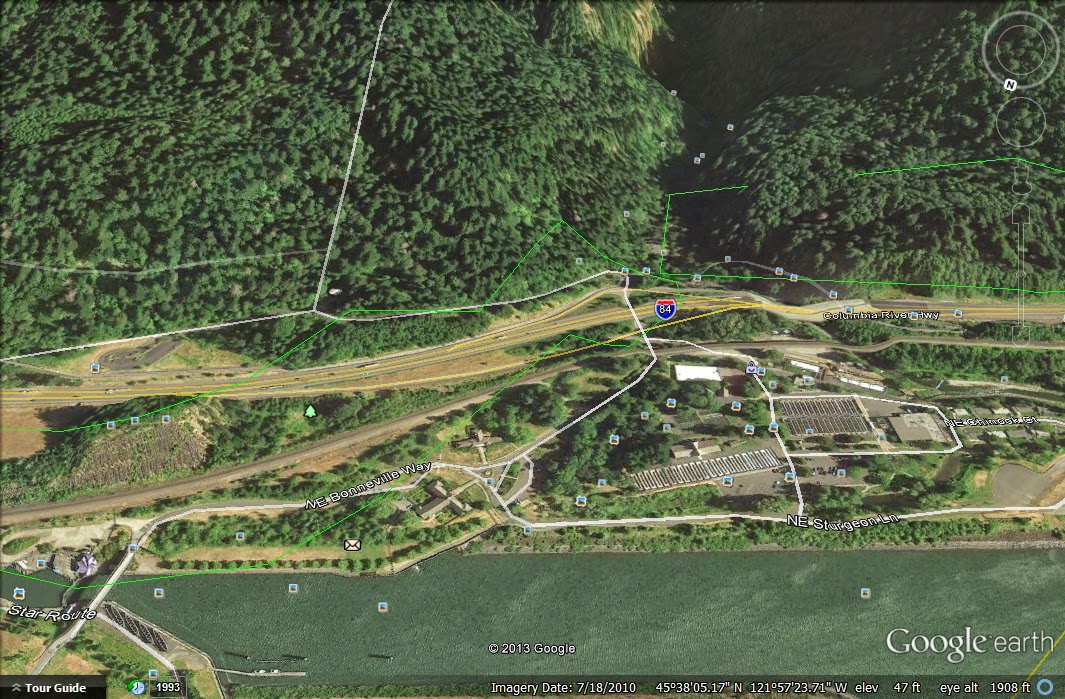
Bell's mansion was on the hill on the east end of the screenshot above, between I-84 and the railroad tracks. The relocation of the rail line to its current route when its former path was flooded by the dam apparently blasted away a large chunk of Mona's hill, and the construction of I-84 apparently took out another large chunk of it, leaving only a sliver of the land that once held her mansion and, consequently, only a small sliver remains of Bonneville State Park. 

UPDATE: March 10, 2014


The Oregonian:
The architectural hash mansion of eccentric Mona Bell Hill was razed for the Bonneville Dam: Historic home series