Showing posts with label ODOT. Show all posts

Monday, March 31, 2014

Old Pavement, Old Lines

Old Lines (2014)

Old Lines (2014)
Original Pavement at Patterson Ferry Road Columbia River Highway. Umatilla National Wildlife Refuge.
Irrigon, Oregon. March 28, 2014
Copyright © 2014 A. F. Litt, All Rights Reserved

The painted lines on the road may offer some clue as to when the various sections of pavement lapsed out of service. 

In many places along the dormant / abandoned sections of the highway, one will find these sorts of stripes, one painted over the other.  Peg Willis explains why:

Sometime between Rexford's innovative striping of the highway and 1954, the centerline color had changed to yellow.  By 1958, the U. S. Bureau of Public Roads mandated white...  But after only two years, the yellow lines were back - at least on the state highways.

Peg Willis. Building the Columbia River Highway: They Said It Couldn’t Be Done. Charleston: The History Press.  2014. 135.

To read more…

Tuesday, March 18, 2014

Bridging A Century of Service: Oregon Department of Transportation - Master Bridge Builder Conde B. McCullough


Bridging A Century of Service - Oregon Department of Transportation - YouTube: "Published on Feb 21, 2013 See the dazzling "Jewel Clasps" of the Oregon Coast and beyond. Learn about the legacy that Conde McCullough gave to Oregon with his stunningly beautiful arch bridges, as the Oregon Department of Transportation celebrates its Centennial of Service."

Wednesday, January 15, 2014

The Original HCRH Route Between Cascade Locks and Wyeth

While the 2006 HCRH Master Plan appears to be correct in that there is only one known existing fragment of the HCRH river route between Herman Creek / Wyeth Road and Wyeth, there is an earlier route, closely following the Herman Creek / Wyeth Road, that seems to be mostly entirely intact.  It is, in fact, the original route of the Wyeth Road itself. 

Considering that the steepness of the existing pavement on the Wyeth Road is a concern of the State Trail Planners, I wonder why they are not already planning on using this route for the trail.  It is less steep, more curvy, and the right size (of course) for a bike path.

A clue on the changing route of the HCRH between Herman Creek and Wyeth from the ODOT 2010 CLI Report:

1914 - Built - Grading of three segments in Hood River County totaling 5.3 miles. (Multnomah / Hood River County line to 1/2 mile west of Cascade Locks - 1.5 miles; east of Wyeth to Shellrock Mountain - 1.7 miles; and Shellrock Mountain to Viento - 2.1 miles.)

I suspect that this work was done in order to connect existing sections of road, as the bridge (the Shellrock Mountain Road) between the Wyeth to Shellrock and the Shellrock to Viento segment was already complete at this time.

1912 - Built - Simon Benson contributed $10,000 for the construction of a new road across Shellrock Mountain. The road was built by Honor prisoners from the State Penitentiary.

So, it follows that the 1914 grading of 1.7 miles between Wyeth and Shellrock was connecting Shellrock to the existing Herman Creek / Wyeth road coming out of Cascade Locks, and this is the route reflected in the earlier 1913 / 1916 USGS map.

Detail - HCRH Herman Creek to Shellrock - Mt. Hood - Edition of March 1913, Reprinted 1916

Later on, the actual HCRH was then built following its own, new route above the river and railway.

1914-1915 - Built - 22 miles were graded from 2 1/2 miles west of Cascade Locks to the city of Hood River.

Detail - HCRH Herman Creek to Lindsey Creek - Hood River - 1926

This seems to clarify some confusion.  In October 2013,  I spoke with a fellow out on an old road grade in this section who told me that the old highway route was over the Wyeth Bench, following the Herman Creek / Wyeth Road. He had worked in many roles in the area over the last 45 years, and spoke of old maps referring to an unpaved road on the south side of the west Wyeth Road slope as being the original highway. Walking this route (pictures below), there were no artifacts that would indicate that it was ever a part of the HCRH, while all of the maps and photos I had seen to this point indicated a river route to the north.

However, for a short period, this route was surely, considering the maps and construction dates,  the original route of the HCRH.

At this point, I am uncertain of this road's origins, but I suspect that it might actually have been the 1872 Wagon Road. If so, this might be the best preserved segment of this route left in the gorge, as it is still driveable and showed signs of recent use (tire tracks).


HCRH - Wyeth Road Route:

The old road, south of the current road, is less steep than the new road, but it does have a lot of twisty curves and a steep drop to the north.  Comparing the Google Earth imagery with the maps above, it is clear that the Wyeth Road route was changed at some point.  

Also, this might be the definitive answer to my power line question.  Here, clearly, the road moved and the power lines stayed behind.

Wyeth Road. The old route, matching the old maps, is visible.
Google Earth. Imagery Date: July 18, 2010
Wyeth Road. The old route (straight line) and the new (large curve).
Google Earth. Imagery Date: July 18, 2010

Old and New Routes Eastbound (2013)
Historic Columbia River Highway. Columbia River Gorge National Scenic Area. Oregon. October 11, 2013.
Copyright © 2014 A. F. Litt, All Rights Reserved

On the right is the original route of both the Wyeth Road and the HCRH, on the left is the modern Wyeth Road and the HCRH State Trail Route.


Tuesday, January 14, 2014

Warren Falls / Hole In the Wall Falls: Collected WyEast Blog Posts by Tom Kloster

Resting at Hole in the Wall Falls

Starvation Creek State Park. Columbia River Gorge National Scenic Area. Oregon. April 26, 2013. A. F. Litt 2013

Restoring Warren Creek Falls | WyEast Blog: "Until the 1930s, Warren Creek was much like it’s neighbors to the east and west in the Columbia River Gorge, plunging in a spectacular waterfall as it reached the final wall of cliffs lining the river. For millennia, the stream had slowly carved a huge amphitheater in sheer basalt, thundering into a deep splash pool at the base of the cliffs, before rushing to the Columbia.

The railroads crossed Warren Creek in the late 1800s, and by the 1920s, Samuel Lancaster’s iconic Historic Columbia River Highway had been constructed, and passed the stream near the falls. Sometime in the late 1930s, the Oregon Highway Department determined that Warren Creek posed a risk to the highway grade, and made the improbable decision to re-route the falls through a tunnel, depositing the stream a few hundred yards to the west."


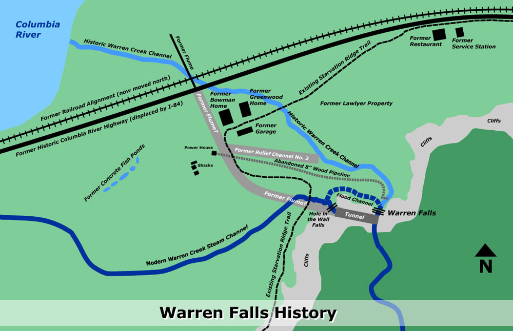
Starvation Creek Loop Hike | WyEast Blog: "After taking in the scene at the former Warren Falls, retrace your steps on the boot path to the footbridge and turn right, continuing along the main trail for your return to the trailhead (note: the restored Historic Columbia River Highway and trail will soon be constructed in this area, with a new trailhead for the Starvation Ridge Trail relocated to this spot). The route briefly passes an open area, and then re-enters forest. Watch for old, stone foundations covered in ivy in this area — you’re passing turn-of-the-century homesteads lost to time. Sharp-eyed hikers will also spot a pair of enormous anthills, each measuring six feet in height. A bit further, and you’ll also pass dome-shaped stone bake ovens, possibly built in the early 1900s by highway workers (see the map below for help in finding these traces of human history in the Warren Falls area)."

Map of Warren Falls History by Tom Kloster  http://wyeastblog.org/2012/06/08/starvation-creek-loop-hike/


 Warren Falls Mystery… Solved! | WyEast Blog: "It was the summer of 1939, and Depression-era Americans were escaping the hard times with the theater releases of “Gone with the Wind” and “The Wizard of Oz”. In Europe, Hitler’s invasion of Poland in September of 1939 ignited World War II.

Against the sweeping backdrop of this pivotal year in history, a odd story was playing out on obscure Warren Creek, near Hood River in the Columbia River Gorge. This is the story of how today’s manmade Hole-in-the-Wall Falls was created, and Warren Falls was (temporarily, at least) lost to time. "

"Historic site map of the Warren Falls diversion project (1939)" Source: WyEast Blog. Tom Kloster. http://wyeastblog.org/2012/01/31/warren-falls-mystery-solved/


Warren Falls Solutions | WyEast Blog: "The strange history of Warren Falls began shortly after completion of the Historic Columbia River Highway in the 1920s, when unruly Warren Creek repeatedly pushed debris against the modest new highway bridge that spanned the stream.

The first Warren Creek bridge was replaced as part of the waterfall diversion; no photos of the original structure survive.


Oregon highway engineers subsequently diverted the creek in 1939 through a bizarre tunnel that survives to this day. The diversion created today’s manmade Hole-in-the-Wall Falls when an accompanying flume was removed sometime in the early 1960s, leaving an eerie, dry cliff where Warren Falls once thundered.

This article proposes a few solutions for restoring Warren Falls to its former glory in tandem with the ongoing ODOT project to restore the Historic Columbia River Highway."

The 1939 construction drawings for the diversion project show the v-shaped vault carved into the lip of Warren Falls, leading to the diversion tunnel (cross-section view)  http://wyeastblog.org/2012/02/27/warren-falls-solutions/


Warren “Barney” Cooper | WyEast Blog: "While tracking down the human history behind the mysterious (and temporarily defunct) falls on Warren Creek in the Columbia River Gorge over the past year, I was surprised to learn that “Warren” is not the surname of a local homesteader or early explorer.

Instead, it is the first name of an early Forest Service ranger, Warren “Barney” Cooper, whose own surname puts him among Mount Hood’s pioneering royalty: the remarkable Coopers of the Hood River Valley."

Warren Falls Lives! (temporarily, at least) | WyEast Blog: "It was remarkable to be in the amphitheater with water cascading over the escarpment, once again, and even if only temporarily. The small amount making its way over the brink completely changed the place from an eerie, somber cavern to a bright, sparkling glen. It was even more exciting to imagine the full force of Warren Creek plunging over the high cliffs, given the thundering display at Hole-in-the-Wall Falls (which is created by the bypass tunnel)."

Warren Falls Lives… Again? | WyEast Blog: "March 16 was a good day for Warren Falls: in the morning, the Historic Columbia River Highway Advisory Committee (AC) allowed me time on their agenda for a second pitch to restore Warren Falls as part of the larger historic highway trail project. After the meeting, I visited Warren Falls and was able to capture it flowing, thanks to the unusually heavy rain we had experienced in early March. Here are the highlights:"

“Warren Falls, we’re ready for your close-up…” | WyEast Blog: "This was the second trip to Warren Falls for Oregon Field Guide producer Vince Patton and videographer Michael Bendixen. Both had joined me for a first look at the area on a particularly icy January day last winter when the Gorge was at its worst — freezing rain and sleet over a crusty layer of snow."

Oregon Field Guide: Warren Falls

"If there’s one thing that makes the Columbia River Gorge stand out, it’s the waterfalls. But did you know that one of those waterfalls is not natural. One waterfall lover wants that man-made waterfall closed down in order to restore Warren Falls, which has been blocked for more than 70 years." Aired: 10/25/2012 - 7:57

“Warren Falls, we’re ready for your close-up…” | WyEast Blog: "This was the second trip to Warren Falls for Oregon Field Guide producer Vince Patton and videographer Michael Bendixen. Both had joined me for a first look at the area on a particularly icy January day last winter when the Gorge was at its worst — freezing rain and sleet over a crusty layer of snow."