Showing posts with label Historical Photos. Show all posts
Showing posts with label Historical Photos. Show all posts
Wednesday, November 18, 2015
Sandy Boulevard
Recreating the Historic Columbia River Highway: Sandy Boulevard from A. F. Litt on Vimeo.
Exploring the Sandy Boulevard, old U.S. 30, alignment of the Columbia River Highway from Milepost Zero in Downtown Portland to the Sandy River Bridge...
RecreatingTheHCRH.org
Music:
"There's Probably No Time" by Chris Zabriskie
freemusicarchive.org/…/03_-_Theres_Probably_No_Time_…
Licensed under a Attribution License.
creativecommons.org/licenses/by/4.0/
"Isolated" by Kevin MacLeod
freemusicarchive.org/…/Kevin_MacLeod/Contem…/Isolated
Licensed under a Creative Commons Attribution License.
creativecommons.org/licenses/by/3.0/

Friday, June 6, 2014
The Dalles Lewis and Clark Monument
A small but interesting piece of history…

Proposed Monument. Lewis and Clark Memorial Association. c. 1930s
Pg 58 in this 1946 State Parks report discusses the monument in the article.
http://arcweb.sos.state.or.us/doc/records/state/odot/pdfs/columbia_gorge.pdf

Location of Lewis and Clark Monument

Monument base before construction of picnic structure. Date Unknown.
Request to nominate the Lewis and Clark Monument for inventory designation to the local Historical Register. City of The Dalles - Historic Landmarks Commission
http://www.ci.the-dalles.or.us/sites/default/files/imported/agendas/planning/historical/PDFs/hlcagenda062613.pdf

Lewis and Clark Monument
Google Street View
The Dalles Lewis and Clark Monument was built prior to World War II starting in 1939. During the War, all work was halted and the project never resumed. In the 1960's, the Dalles Lions Club constructed a picnic shelter surrounding the Monument. Over the past decades, the structure has fallen into disrepair and posses a safety risk for users of the new skate park that is located next to the monument. A decision to remove the structure and donate the usable materials to The Dalles Parks and Recreation for future construction of new smaller shelters was approved.
https://www.facebook.com/TheDallesLewisAndClarkMonumentProject/info
Request to nominate the Lewis and Clark Monument for inventory designation to the local Historical Register. 2013. City of The Dalles - Historic Landmarks Commission

Via Peg Willis ( Building the Columbia River Highway )
Monday, May 19, 2014
The Other Cape Horn…
This is the Cape Horn between The Dalles and Celilo, not the one we think of today...
http://www.northwestphotography.org/Plate11.html
Plate 11: Cape Horn, Near Celilo
Carleton E. Watkins
Albumen silver mammoth print, 1867

http://www.northwestphotography.org/Plate80.html
Plate 80: Upper Cape Horn
Lily E. White
Platinum print, 1903-1905


This is pretty clearly west of Celilo.
The CRH East of Celilo Falls
Clarence E. Mershon. The Columbia River Highway: From the Sea to the Wheat Fields of Eastern Oregon. Portland: Guardian Peaks Enterprises. 2006. 1st Edition. 223.

Not sure when, or if ever, it was called Applegate Point…
Columbia Gorge Discovery Center Photo Archive
Catalog Num: 1999.13.94BB
Condition: Good
Date:
Location: The Dalles, Oregon
Title:
Content: No. 160. Applegate Point, on Old Oregon - Trail Highway, near Celilo Ore.
Other Notes: description from above on front no correspondence "sample"
Photographer: B.C. Markham, The Dalles, Oregon
Copyright:http://www.gorgediscovery.org/photoarchive/newDetails.asp?offset=980&ID=2706

Cliffs East of The Dalles (2014)
General area of the Columbia River Highway.
Wasco County, Oregon. March 28, 2014
Copyright © 2014 A. F. Litt, All Rights Reserved

First two photos from Wild Beauty: Photography of the Columbia River Gorge, 1867-1957
Monday, March 31, 2014
Then & Now: West of Celilo
This photo below is approaching the cliffs seen in the "Cape Horn" photo below it.
Cliffs East of The Dalles (2014)
Wasco County, Oregon. March 28, 2014
Copyright © 2014 A. F. Litt, All Rights Reserved
The CRH East of Celilo Falls
Clarence E. Mershon. The Columbia River Highway: From the Sea to the Wheat Fields of Eastern Oregon. Portland: Guardian Peaks Enterprises. 2006. 1st Edition. 223.
This photo is pretty clearly mislabeled.
I suppose there might have been a mistake made locating the photo since these cliffs resemble the one where the old tunnel was, west of the Deschutes River and east of Celilo Falls.
Looking at the imagery below from Google Earth, though, there is little doubt that the location of the old photo is between The Dalles Dam and the Trunk Railroad crossing.

CRH "East" Of Celilo Falls Location, I-84 Westbound Lanes
Google Street View Imagery Date: October 2007

CRH "East" Of Celilo Falls Location, I-84 Eastbound Lanes
Google Street View Imagery Date: December 2007

CRH "East" Of Celilo Falls Location, Ground Level
Google Earth Imagery Date: August 19, 2011
If this is the correct location of the old photo, then there are probably traces of the old highway underwater in the pond south of the freeway.

CRH "East" Of Celilo Falls Location
Google Earth Imagery Date: August 19, 2011

No. 160. Applegate Point, on Old Oregon - Trail Highway, near Celilo Ore.
Columbia Gorge Discovery Center Photo Archive
Catalog Num: 1999.13.94BB
Condition: Good
Date:
Location: The Dalles, Oregon
Title:
Content: No. 160. Applegate Point, on Old Oregon - Trail Highway, near Celilo Ore.
Other Notes: description from above on front no correspondence "sample"
Photographer: B.C. Markham, The Dalles, Oregon
Copyright:
http://www.gorgediscovery.org/photoarchive/newDetails.asp?offset=980&ID=2706
Friday, March 14, 2014
Official Designations of Oregon State Highways in 1918

TABLE J
OFFICIAL DESIGNATION OF STATE HIGHWAYS
No. 1. Pacific Highway—
From Portland south via Oregon City, Salem, Albany, Eugene, Roseburg, Grants Pass, Medford and Ashland to the Oregon-California State Line.
From Portland south via Oregon City, Salem, Albany, Eugene, Roseburg, Grants Pass, Medford and Ashland to the Oregon-California State Line.
No. 2. Columbia River Highway—
From Astoria east via Rainier, Portland, Hood River, The Dalles, Arlington and Umatilla, to Pendleton.
From Astoria east via Rainier, Portland, Hood River, The Dalles, Arlington and Umatilla, to Pendleton.
No. 3. Coast Highway—
From Astoria south via Tillamook, Toledo, Florence, Marshfield, Coquille and Gold Beach to Oregon-California State Line.
From Astoria south via Tillamook, Toledo, Florence, Marshfield, Coquille and Gold Beach to Oregon-California State Line.
No. 4. The Dalles-California Highway—
From a point on Highway No. 2, at or near The Dalles, south via Shaniko, Redmond, Bend, LaPine and Klamath Falls to the Oregon-California State Line.
From a point on Highway No. 2, at or near The Dalles, south via Shaniko, Redmond, Bend, LaPine and Klamath Falls to the Oregon-California State Line.
No. 5. The John Day River Highway—
From a point on Highway No. 2, at or near Biggs, southeasterly through Wasco, Condon, Fossil, Dayville, Prairie City and Vale to the Oregon-Idaho State Line at Ontario.
From a point on Highway No. 2, at or near Biggs, southeasterly through Wasco, Condon, Fossil, Dayville, Prairie City and Vale to the Oregon-Idaho State Line at Ontario.
No. 6. The Old Oregon Trail—
From a junction with Highway No. 2, at Pendleton, southeasterly through La Grande, Baker and Huntington to a junction with Highway No. 5 at or near Ontario.
From a junction with Highway No. 2, at Pendleton, southeasterly through La Grande, Baker and Huntington to a junction with Highway No. 5 at or near Ontario.
No. 7. Central Oregon Highway—
From a point on Highway No. 4, at or near Bend, easterly through Millican, Riley, Burns, Crane and Juntura to a junction with Highway No. 5, at or near Vale.
From a point on Highway No. 4, at or near Bend, easterly through Millican, Riley, Burns, Crane and Juntura to a junction with Highway No. 5, at or near Vale.
No. 8. Oregon-Washington Highway—
From a point on Highway No. 2, at or near Willows, through Ione, Heppner, Pendleton and Freewater to the Oregon-Washington State Line.
From a point on Highway No. 2, at or near Willows, through Ione, Heppner, Pendleton and Freewater to the Oregon-Washington State Line.
No. 9. Pendleton-John Day Highway—
From a point on Highway No. 8, at or near Pilot Rock south to a junction with Highway No. 5, at or near John Day.
From a point on Highway No. 8, at or near Pilot Rock south to a junction with Highway No. 5, at or near John Day.
No. 10. La Grande-Enterprise Highway—
From a point on Highway No. 6, at or near La Grande, through Elgin and Enterprise to Joseph.
From a point on Highway No. 6, at or near La Grande, through Elgin and Enterprise to Joseph.
No. 11. Enterprise-Flora Highway—
From a point on Highway No. 10, at or near Enterprise, north to Flora.
From a point on Highway No. 10, at or near Enterprise, north to Flora.
No. 12. Baker-Cornucopia Highway—
From a point on Highway No. 6, at or near Baker, east through Middle Bridge and Halfway to Cornucopia.
From a point on Highway No. 6, at or near Baker, east through Middle Bridge and Halfway to Cornucopia.
No. 13. Baker-Unity Highway—
From a point on Highway No. 6, at or near Baker, southwest to a junction with Highway No. 5, at or near Unity.
From a point on Highway No. 6, at or near Baker, southwest to a junction with Highway No. 5, at or near Unity.
No. 14. Antelope-Mitchell Highway—
From a point on Highway No. 4, at or near Antelope to a junction with Highway No. 15, at or near Mitchell.
From a point on Highway No. 4, at or near Antelope to a junction with Highway No. 15, at or near Mitchell.
No. 15. McKenzie River Highway—
From a point on Highway No. 1, at or near Eugene, easterly through the McKenzie Valley and through Sisters, Redmond, Prineville and Mitchell to a junction with Highway No. 5, at or near Dayville.
From a point on Highway No. 1, at or near Eugene, easterly through the McKenzie Valley and through Sisters, Redmond, Prineville and Mitchell to a junction with Highway No. 5, at or near Dayville.
No. 16. Albany-Sisters Highway—
From a point on Highway No. 4, at or near Albany, southeasterly to a junction with Highway No. 15 near Sisters.
From a point on Highway No. 4, at or near Albany, southeasterly to a junction with Highway No. 15 near Sisters.
No. 17. Bend-Sisters Highway—
From a point on Highway No. 4, at or near Bend, northwesterly to a junction with Highway No. 15, at or near Sisters.
From a point on Highway No. 4, at or near Bend, northwesterly to a junction with Highway No. 15, at or near Sisters.
No. 18. Lakeview-Burns Highway—
From a point on Highway No. 19, near Lakeview, northeasterly to a junction with Highway No. 7, at or near Burns.
From a point on Highway No. 19, near Lakeview, northeasterly to a junction with Highway No. 7, at or near Burns.
No. 19. LaPine-Lakeview Highway—
From a point on Highway No. 4, at or near LaPine southeasterly through Fort Rock, Silver Lake, Paisley and Lakeview to the Oregon-California State Line.
From a point on Highway No. 4, at or near LaPine southeasterly through Fort Rock, Silver Lake, Paisley and Lakeview to the Oregon-California State Line.
No. 20. Klamath Falls-Lakeview Highway—
From a point on Highway No. 4, at or near Klamath Falls, east to a junction with Highway No. 19, at or near Lakeview.
From a point on Highway No. 4, at or near Klamath Falls, east to a junction with Highway No. 19, at or near Lakeview.
No. 21. Ashland-Klamath Falls Highway—
From a point on Highway No. 1 near Ashland, east to a junction with Highway No. 4, at or near Klamath Falls.
From a point on Highway No. 1 near Ashland, east to a junction with Highway No. 4, at or near Klamath Falls.
No.22. Medford-Crater Lake Highway—[64]
From a point on Highway No. 1 at Medford, northeasterly, through Trail and the Rogue River Valley to a junction with Highway No. 24 near Crater Lake.
From a point on Highway No. 1 at Medford, northeasterly, through Trail and the Rogue River Valley to a junction with Highway No. 24 near Crater Lake.
No. 23. Klamath-Crater Lake Highway—
From a junction with Highway No. 22 near Crater Lake, southeasterly to a junction with Highway No. 4, at or near Chiloquin.
From a junction with Highway No. 22 near Crater Lake, southeasterly to a junction with Highway No. 4, at or near Chiloquin.
No. 24. The Rim Highway—
From a point on Highway No. 22 near Crater Lake, thence around Crater Lake to the point of beginning.
From a point on Highway No. 22 near Crater Lake, thence around Crater Lake to the point of beginning.
No. 25. Grants Pass-Crescent City Highway—
From a point on Highway No. 1 at Grants Pass, southwesterly through Kerby and Waldo to the Oregon-California State Line.
From a point on Highway No. 1 at Grants Pass, southwesterly through Kerby and Waldo to the Oregon-California State Line.
No. 26. Mt. Hood Highway—
From Portland through Gresham and Bull Run around the south and east sides of Mt. Hood and to a junction with Highway No. 2, at or near Hood River.
From Portland through Gresham and Bull Run around the south and east sides of Mt. Hood and to a junction with Highway No. 2, at or near Hood River.
No. 27. Clackamas Highway—
From a point on Highway No. 1, at or near Oregon City, northeasterly to a junction with Highway No. 26, at or near Pleasant Home.
From a point on Highway No. 1, at or near Oregon City, northeasterly to a junction with Highway No. 26, at or near Pleasant Home.
No. 28. The West Side Highway—
From a point on Highway No. 1, at or near Portland, thence south on the west side of the Willamette River through Newberg, McMinnville, Dallas, Independence and Corvallis to a junction with Highway No. 1, at or near Eugene.
From a point on Highway No. 1, at or near Portland, thence south on the west side of the Willamette River through Newberg, McMinnville, Dallas, Independence and Corvallis to a junction with Highway No. 1, at or near Eugene.
No. 29. Forest Grove-McMinnville Highway—
From Portland through Hillsboro, Forest Grove and Carlton to a junction with Highway No. 28, at or near McMinnville.
From Portland through Hillsboro, Forest Grove and Carlton to a junction with Highway No. 28, at or near McMinnville.
No. 30. Salem-Independence Highway—
From a point on Highway No. 1, at Salem, southwesterly to a junction with Highway No. 28 at Independence.
From a point on Highway No. 1, at Salem, southwesterly to a junction with Highway No. 28 at Independence.
No. 31. Albany-Corvallis Highway—
From a point on Highway No. 1, at Albany to a junction with Highway No. 28, at or near Corvallis.
From a point on Highway No. 1, at Albany to a junction with Highway No. 28, at or near Corvallis.
No. 32. Yamhill-Nestucca Highway—
From a point on Highway No. 28, at or near McMinnville, through Sheridan, Willamina, and Dolph to a junction with Highway No. 3, at or near Hebo.
From a point on Highway No. 28, at or near McMinnville, through Sheridan, Willamina, and Dolph to a junction with Highway No. 3, at or near Hebo.
No. 33. Corvallis-Newport Highway—
From a point on Highway No. 28, at Corvallis westerly to a junction with Highway No. 3, at or near Toledo.
From a point on Highway No. 28, at Corvallis westerly to a junction with Highway No. 3, at or near Toledo.
No. 34. Eugene-Florence Highway—
From a point on Highway No. 1, near Eugene, westerly through Goldson and Deadwood to a junction with Highway No. 3, near Florence.
From a point on Highway No. 1, near Eugene, westerly through Goldson and Deadwood to a junction with Highway No. 3, near Florence.
No. 35. Coos Bay-Roseburg Highway—
From a point on Highway No. 3, at or near Coquille, easterly up the Middle Fork of the Coquille River, through Camas Valley and Brockway to a junction with Highway No. 1, near Dillard.
From a point on Highway No. 3, at or near Coquille, easterly up the Middle Fork of the Coquille River, through Camas Valley and Brockway to a junction with Highway No. 1, near Dillard.
No. 36. Pendleton-Cold Springs Highway—
From a point on Highway No. 2, at or near Pendleton, northwest to Cold Springs.
TABLE L
From a point on Highway No. 2, at or near Pendleton, northwest to Cold Springs.
TABLE L
STATE HIGHWAYS
Names, Numbers, Mileages.
| Highways | Miles | ||
| No. | 1 | Pacific Highway | 352 |
| No. | 2 | Columbia River Highway | 360 |
| No. | 3 | Coast Highway | 430 |
| No. | 4 | The Dalles-California Highway | 342 |
| No. | 5 | The John Day River Highway | 285 |
| No. | 6 | The Old Oregon Trail | 190 |
| No. | 7 | Central Oregon Highway | 270 |
| No. | 8 | Oregon-Washington Highway | 148 |
| No. | 9 | Pendleton-John Day Highway | 105 |
| No. | 10 | La Grande-Enterprise Highway | 68 |
| No. | 11 | Enterprise-Flora Highway | 35 |
| No. | 12 | Baker-Cornucopia Highway | 76 |
| No. | 13 | Baker-Unity Highway | 42 |
| No. | 14 | Antelope-Mitchell Highway | 43 |
| No. | 15 | McKenzie River Highway | 229 |
| No. | 16 | Albany-Sisters Highway | 100 |
| No. | 17 | Bend-Sisters Highway | 27 |
| No. | 18 | Lakeview-Burns Highway | 159 |
| No. | 19 | LaPine-Lakeview Highway | 151 |
| No. | 20 | Klamath Falls-Lakeview Highway | 100 |
| No. | 21 | Ashland-Klamath Falls Highway | 51 |
| No. | 22 | Medford-Crater Lake Highway | 78 |
| No. | 23 | Klamath-Crater Lake Highway | 14 |
| No. | 24 | The Rim Highway | 39 |
| No. | 25 | Grants Pass-Crescent City Highway | 46 |
| No. | 26 | Mt. Hood Highway | 105 |
| No. | 27 | Clackamas Highway | 18 |
| No. | 28 | The West Side Highway | 120 |
| No. | 29 | Forest Grove-McMinnville Highway | 25 |
| No. | 30 | Salem-Independence Highway | 12 |
| No. | 31 | Albany-Corvallis Highway | 11 |
| No. | 32 | Yamhill-Nestucca Highway | 39 |
| No. | 33 | Corvallis-Newport Highway | 60 |
| No. | 34 | Eugene-Florence Highway | 76 |
| No. | 35 | Coos Bay-Roseburg Highway | 81 |
| No. | 36 | Pendleton-Cold Springs Highway | 30 |
| Total mileage State Highways | 4,317 | ||
Source:
The Project Gutenberg EBook of Third Biennial Report of the Oregon State
Highway Commission, by S. Benson, W. L. Thompson, R. A. Booth, Herbert Nunn

This eBook is for the use of anyone anywhere at no cost and with
almost no restrictions whatsoever.  You may copy it, give it away or
re-use it under the terms of the Project Gutenberg License included
with this eBook or online at www.gutenberg.org


Title: Third Biennial Report of the Oregon State Highway Commission
       Covering the Period December 1st, 1916 to November 30th, 1918

Author: S. Benson, W. L. Thompson, R. A. Booth, Herbert Nunn

Release Date: February 21, 2011 [EBook #35344]
http://www.gutenberg.org/files/35344/35344-h/35344-h.htm#TabJ
Lower Columbia River Highway: Prescott Point / Little Jack Falls Abandoned Segment
Until a few weeks ago, I naively assumed that most of the current U.S. 30 route out to the coast followed the original path of the original CRH. I was very wrong, and it appears that there may be even more abandoned segments out to the west than there are in the Gorge.
This is a pretty spectacular one, from what I've seen so far online. I plan on visiting in person ASAP.

 .94 Mile Little Jack Falls Segment of Abandoned Columbia River Highway
Google Earth. Imagery Date: April 19, 2009
 REINFORCED CONCRETE CRIBBING NEAR PRESCOTT ON THE COLUMBIA RIVER HIGHWAY IN COLUMBIA COUNTY. BUILT IN 1918
Third Biennial Report of the Oregon State Highway Commission Covering the Period December 1st, 1916 to November 30th, 1918
http://www.gutenberg.org/files/35344/35344-h/35344-h.htm#Fig05
 REINFORCED CONCRETE HALF VIADUCT ON THE COLUMBIA RIVER HIGHWAY BETWEEN GOBLE AND RAINIER IN COLUMBIA COUNTY, CONSTRUCTED IN 1918
Third Biennial Report of the Oregon State Highway Commission Covering the Period December 1st, 1916 to November 30th, 1918
http://www.gutenberg.org/files/35344/35344-h/35344-h.htm#Fig04
 Scenic Stretch, Lower Columbia River Highway
Clarence E. Mershon. The Columbia River Highway: From the Sea to the Wheat Fields of Eastern Oregon. Portland: Guardian Peaks Enterprises. 2006. 1st Edition. 35.
 Prescott Point
Clarence E. Mershon. The Columbia River Highway: From the Sea to the Wheat Fields of Eastern Oregon. Portland: Guardian Peaks Enterprises. 2006. 1st Edition. 35.
 The CRH West of Little Jack Falls
"Cross & Dimmit postcard courtesy of David Sell."
Clarence E. Mershon. The Columbia River Highway: From the Sea to the Wheat Fields of Eastern Oregon. Portland: Guardian Peaks Enterprises. 2006. 1st Edition. 36.
 CRH West of Little Jack Falls (Pre-2006)
Photo by Clarence E. Mershon.
Clarence E. Mershon. The Columbia River Highway: From the Sea to the Wheat Fields of Eastern Oregon. Portland: Guardian Peaks Enterprises. 2006. 1st Edition. 36.
 LITTLE JACK FALLS ON THE COLUMBIA RIVER HIGHWAY BETWEEN GOBLE AND RAINIER IN COLUMBIA COUNTY
Third Biennial Report of the Oregon State Highway Commission Covering the Period December 1st, 1916 to November 30th, 1918
http://www.gutenberg.org/files/35344/35344-h/35344-h.htm#Fig01
 Little Jack Falls On Columbia River Highway
http://www.waterfallsnorthwest.com/nws/falls.php?num=4098


Waterfall trip from Astoria to Portland on hwy 30 2/16
This is a pretty spectacular one, from what I've seen so far online. I plan on visiting in person ASAP.
Little Jack Abandoned Segment, Little Jack Falls Road, and Lindberg Road Sections of original CRH
DOGAMI Lidar
http://www.oregongeology.org/dogamilidarviewer/
DOGAMI Lidar
http://www.oregongeology.org/dogamilidarviewer/
Google Earth. Imagery Date: April 19, 2009
Third Biennial Report of the Oregon State Highway Commission Covering the Period December 1st, 1916 to November 30th, 1918
http://www.gutenberg.org/files/35344/35344-h/35344-h.htm#Fig05
Third Biennial Report of the Oregon State Highway Commission Covering the Period December 1st, 1916 to November 30th, 1918
http://www.gutenberg.org/files/35344/35344-h/35344-h.htm#Fig04
Clarence E. Mershon. The Columbia River Highway: From the Sea to the Wheat Fields of Eastern Oregon. Portland: Guardian Peaks Enterprises. 2006. 1st Edition. 35.
Clarence E. Mershon. The Columbia River Highway: From the Sea to the Wheat Fields of Eastern Oregon. Portland: Guardian Peaks Enterprises. 2006. 1st Edition. 35.
[Below] The Columbia River Highway between Prescott Point and Little Jack Falls shortly after the stretch was paved.
Clarence E. Mershon. The Columbia River Highway: From the Sea to the Wheat Fields of Eastern Oregon. Portland: Guardian Peaks Enterprises. 2006. 1st Edition. 36.
"Cross & Dimmit postcard courtesy of David Sell."
Clarence E. Mershon. The Columbia River Highway: From the Sea to the Wheat Fields of Eastern Oregon. Portland: Guardian Peaks Enterprises. 2006. 1st Edition. 36.
[Below] The old highway (same location) is now strewn with rocks and overrun with brambles, but does provide a difficult path to reach the falls. The cooling tower (demolished in May, 2006) for the Trojan nuclear power plant is visible in the background.
Clarence E. Mershon. The Columbia River Highway: From the Sea to the Wheat Fields of Eastern Oregon. Portland: Guardian Peaks Enterprises. 2006. 1st Edition. 36.
Photo by Clarence E. Mershon.
Clarence E. Mershon. The Columbia River Highway: From the Sea to the Wheat Fields of Eastern Oregon. Portland: Guardian Peaks Enterprises. 2006. 1st Edition. 36.
Third Biennial Report of the Oregon State Highway Commission Covering the Period December 1st, 1916 to November 30th, 1918
http://www.gutenberg.org/files/35344/35344-h/35344-h.htm#Fig01
http://www.waterfallsnorthwest.com/nws/falls.php?num=4098
Little Jack Falls
"The approach to the scenic wayside at Little Jack Falls on the original CRH. Photo courtesy of Steve Lehl."
"The approach to the scenic wayside at Little Jack Falls on the original CRH. Photo courtesy of Steve Lehl."
Clarence E. Mershon. The Columbia River Highway: From the Sea to the Wheat Fields of Eastern Oregon. Portland: Guardian Peaks Enterprises. 2006. 1st Edition. 37.
Little Jack Falls and Jack Falls Creeks
There are some nice pictures of this segment from these trip reports these folks put together..
Monday, January 13, 2014
When the HCRH & I-84 First Meet: Puzzling Out the Original HCRH Alignment Through Dodson & Warrendale
Excerpted from:

UPDATE: September 6, 2014
After looking at this for over a year now, tearing my hair out, and just jumping up and down being mad, I am, for the most part, now willing to accept that the Frontage Road is the original Route 2 alignment.
However, I still want to know what is going on with the over-engineered parts of Enquist and Warrendale Roads!
The HCRH Meets The Interstate
Historic Columbia River Highway. Columbia River Gorge National Scenic Area. Oregon. April 23, 2013
Historic Columbia River Highway. Columbia River Gorge National Scenic Area. Oregon. April 23, 2013
In the photo below, from left to right, north to south, are Tumalt Road, Warrendale Road, I-84, NE Frontage Road, and a mysterious winding track through the woods. But which, if any, is the original historic highway?

Tumalt Road, Warrendale Road, I-84, NE Frontage Road, and a mysterious winding track through the woods.
Google Earth. Imagery Date: July 18, 2010
Monday, January 6, 2014
Lindsey Creek & Lindsey Pond

Lindsey Lake and the Gorge East From HCRH State Trail Route (2013)
Lindsey Creek State Park. Columbia River Gorge National Scenic. Oregon. November 1, 2013.
Lindsey Creek State Park. Columbia River Gorge National Scenic. Oregon. November 1, 2013.
From:
Lindsey Creek was named for John Lindsey, an early homesteader. The creek heads at North Lake and flows northeast into the Columbia River at Lindsey Pond, 2.5 miles north of Mount Defiance. The mouth is located at Columbia River Mile (RM) 159. Lindsey Pond is separated from the Columbia by a levee for the Union Pacific Railroad tracks. Upstream of Lindsey Creek is Wonder Creek and Starvation Creek and State Park and downstream is Summit Creek and Shellrock Mountain. The U.S. Board of Geographic Names made "Lindsey Creek" the official name in 1995. In the 1930s the Union Pacific Railroad had a station named Lindsey.
The original Lindsey Pond is seen in the foreground of the photo below, though the whole architecture of the river through here has changed since this photo was shot, and the old, apparently somewhat natural pond is, really, no more, just a small man-made lagoon created by the railroad tracks.Lyn Topinka. The Columbia River: A Photographic Journey.

Columbia Gorge Discovery Center Photo Archive
Catalog Num: 2000.16.10
Condition: Good
Date:
Location: Columbia River Highway, Oregon
Title:
Content: Wind Mountain and sunset skies
Other Notes:
Photographer: Eddy
Copyright: Eddy
http://www.gorgediscovery.org/photoarchive/newDetails.asp?offset=780&ID=2428
Catalog Num: 2000.16.10
Condition: Good
Date:
Location: Columbia River Highway, Oregon
Title:
Content: Wind Mountain and sunset skies
Other Notes:
Photographer: Eddy
Copyright: Eddy
http://www.gorgediscovery.org/photoarchive/newDetails.asp?offset=780&ID=2428

CRH between Shellrock Mountain and Starvation Creek
Clarence E. Mershon. The Columbia River Highway: From the Sea to the Wheat Fields of Eastern Oregon. Portland: Guardian Peaks Enterprises. 2006. 1st Edition. 186
Clarence E. Mershon. The Columbia River Highway: From the Sea to the Wheat Fields of Eastern Oregon. Portland: Guardian Peaks Enterprises. 2006. 1st Edition. 186
Looks like the old lake's level was pretty variable. More of a slough than a lake, really.

All of the land visible on this map north of the train tracks and highway is now gone. However, it is still there in the photo above. Lindsey Pond is also, essentially, gone.


"Baldock’s faster, straighter version of the Columbia River Highway began to emerge in the 1940s"
Tom Kloster. WyEast Blog: Warren Falls Mystery… Solved! http://wyeastblog.org/2012/01/31/warren-falls-mystery-solved/
Saturday, January 4, 2014
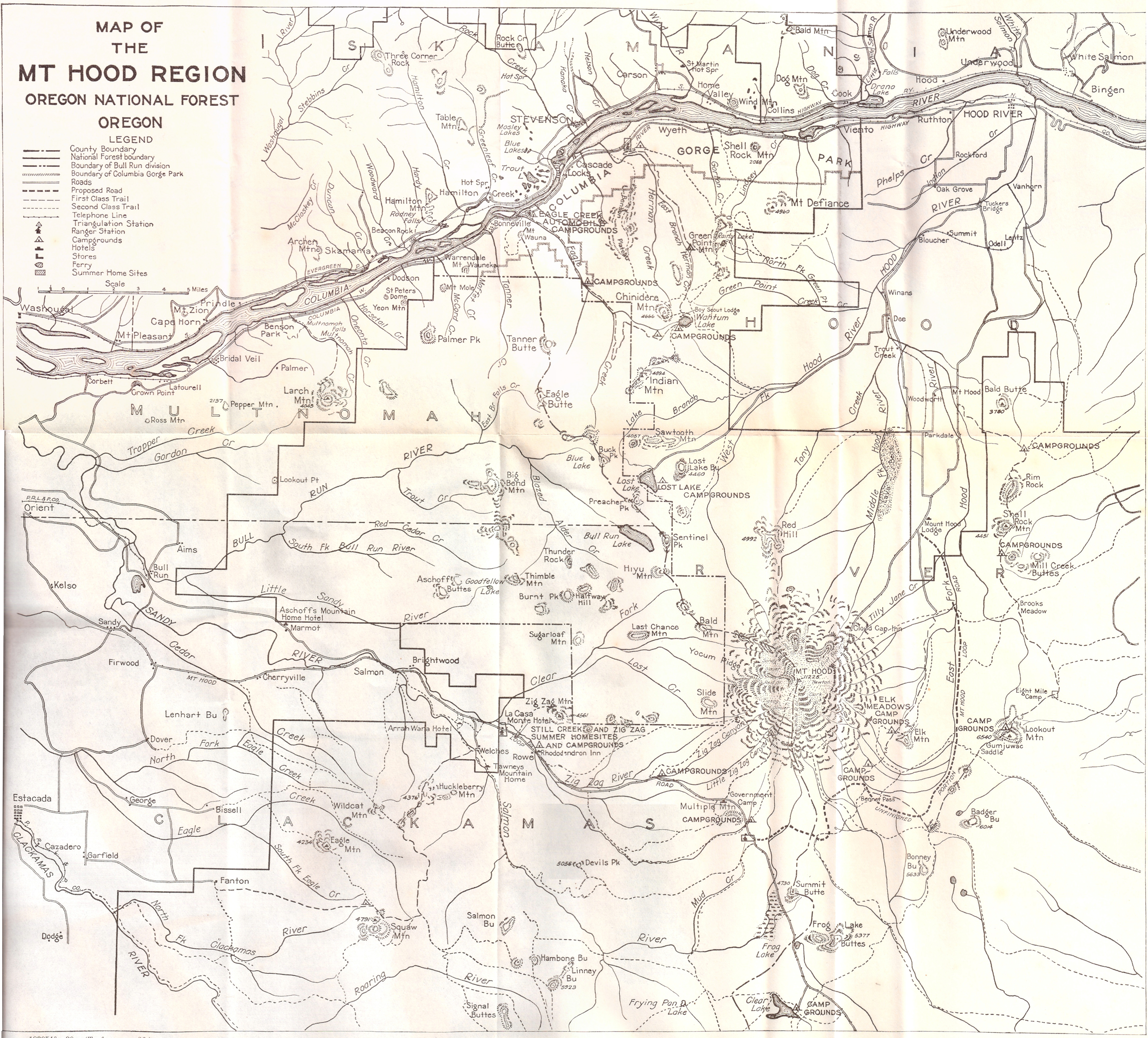
1920 Brochure - Forest trails and highways of the Mount Hood Region
Originally posted on Rubble on October 10, 2013:
http://rubble.blogspot.com/2013/10/1920-brochure-forest-trails-and.html
Forest trails and highways of the Mount Hood re...: 'via Blog this'


http://rubble.blogspot.com/2013/10/1920-brochure-forest-trails-and.html
Forest trails and highways of the Mount Hood re...: 'via Blog this'

Lancaster's Lodge and Retirement Cabin at Tanner Creek (UPDATED: March 20, 2014)
Originally posted on Rubble on September 20, 2013:
http://rubble.blogspot.com/2013/09/lancasters-logde-and-retirement-cabin.html
Several of us were discussing Lancaster's retirement during the weekend of the Yeon to Moffett Creek HCRH Trail Dedication... Apparently, I was combining two different stories. I was saying that Lancaster retired on Bell's property, but these were two different locations.
"Samuel Lancaster built a private 72-acre campground at Bonneville that overlooked Bradford Island and the lower Cascade rapids. He constructed a log dining hall and tent 'cabins' at camping areas. Lancaster used facilities he had observed in Switzerland as a model for his development. The log structure burned in the late 1920s and was not replaced. In 1928, Sam Hill built a 22-room house on a 35-acre estate at Bonneville for his 'friend' Mona Bell. Because the property was required for the construction of Bonneville Dam, the government purchased the estate in 1934." - Clarence E. Mershon, The Columbia River Highway: From the Sea to the Wheat Fields of Eastern Oregon
"...while across the road Lancaster established a campground and recreational facility, Camp Get-A-Way." - Clarence E. Mershon, East of the Sandy: The Columbia River Highway
"In the 20s, Sam Hill built a large home on top of the large rock formation north of I-84, east of exit 40. The house was razed in the late 50s." - Clarence E. Mershon, East of the Sandy: The Columbia River Highway
.jpg)
.jpg)
.jpg)
.jpg)
.jpg)
Additional photos from Scott Cook / Curious Gorge:
The long-gone Mona Bell mansion built by Sam Hill for his mistress Mona Bell:
http://www.panoramio.com/photo/52098770
Mona Bell's one-time mansion atop Bonneville Rock:
http://www.panoramio.com/photo/74053683
Remnant foundation of Mona Bell Hill's mansion:
http://www.panoramio.com/photo/74053689

Bell's mansion was on the hill on the east end of the screenshot above, between I-84 and the railroad tracks. The relocation of the rail line to its current route when its former path was flooded by the dam apparently blasted away a large chunk of Mona's hill, and the construction of I-84 apparently took out another large chunk of it, leaving only a sliver of the land that once held her mansion and, consequently, only a small sliver remains of Bonneville State Park.
UPDATE: March 10, 2014
http://rubble.blogspot.com/2013/09/lancasters-logde-and-retirement-cabin.html
Several of us were discussing Lancaster's retirement during the weekend of the Yeon to Moffett Creek HCRH Trail Dedication... Apparently, I was combining two different stories. I was saying that Lancaster retired on Bell's property, but these were two different locations.
"Samuel Lancaster built a private 72-acre campground at Bonneville that overlooked Bradford Island and the lower Cascade rapids. He constructed a log dining hall and tent 'cabins' at camping areas. Lancaster used facilities he had observed in Switzerland as a model for his development. The log structure burned in the late 1920s and was not replaced. In 1928, Sam Hill built a 22-room house on a 35-acre estate at Bonneville for his 'friend' Mona Bell. Because the property was required for the construction of Bonneville Dam, the government purchased the estate in 1934." - Clarence E. Mershon, The Columbia River Highway: From the Sea to the Wheat Fields of Eastern Oregon
"...while across the road Lancaster established a campground and recreational facility, Camp Get-A-Way." - Clarence E. Mershon, East of the Sandy: The Columbia River Highway
"In the 20s, Sam Hill built a large home on top of the large rock formation north of I-84, east of exit 40. The house was razed in the late 50s." - Clarence E. Mershon, East of the Sandy: The Columbia River Highway
.jpg)
.jpg)
.jpg)
.jpg)
.jpg)
Additional photos from Scott Cook / Curious Gorge:
The long-gone Mona Bell mansion built by Sam Hill for his mistress Mona Bell:
http://www.panoramio.com/photo/52098770
Mona Bell's one-time mansion atop Bonneville Rock:
http://www.panoramio.com/photo/74053683
Remnant foundation of Mona Bell Hill's mansion:
http://www.panoramio.com/photo/74053689
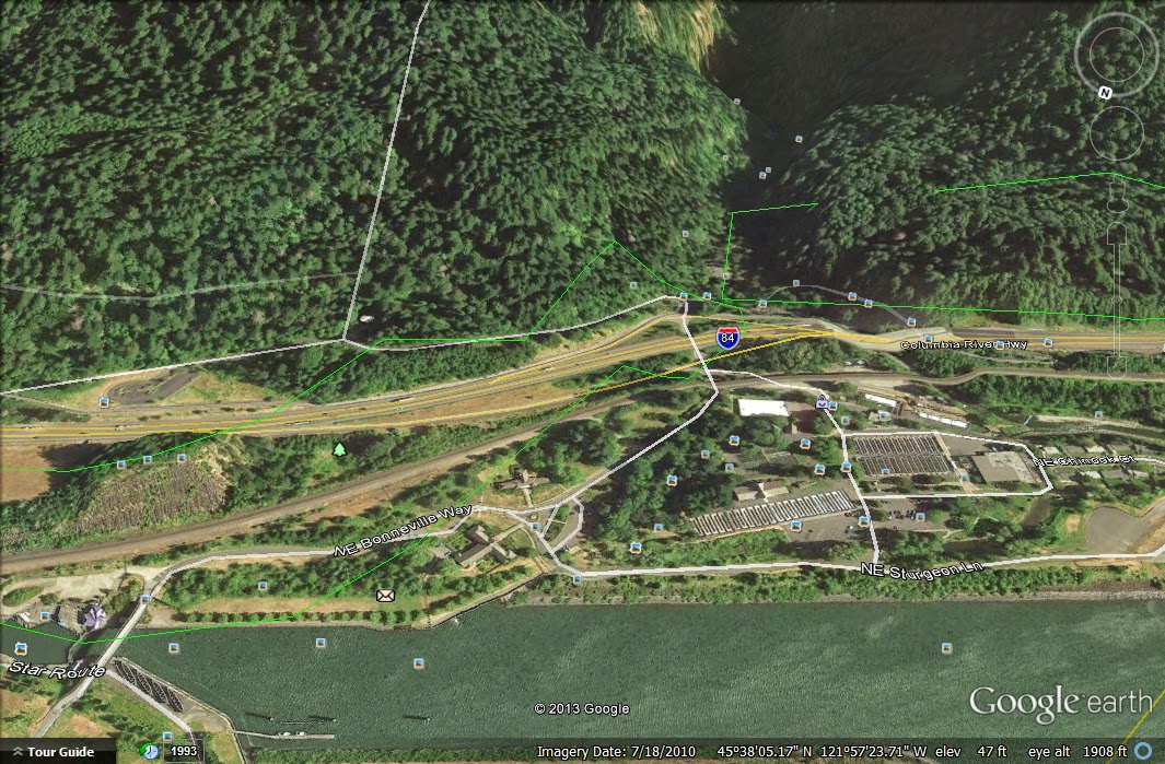
Bell's mansion was on the hill on the east end of the screenshot above, between I-84 and the railroad tracks. The relocation of the rail line to its current route when its former path was flooded by the dam apparently blasted away a large chunk of Mona's hill, and the construction of I-84 apparently took out another large chunk of it, leaving only a sliver of the land that once held her mansion and, consequently, only a small sliver remains of Bonneville State Park.
UPDATE: March 10, 2014
The Oregonian:
The architectural hash mansion of eccentric Mona Bell Hill was razed for the Bonneville Dam: Historic home series
The architectural hash mansion of eccentric Mona Bell Hill was razed for the Bonneville Dam: Historic home series
First Nations of the Gorge: Columbia Gorge Discovery Center Photo Archive
Originally posted on Rubble on October 15, 2013:
http://rubble.blogspot.com/2013/10/first-nations-of-gorge-columbia-gorge.html
Since I will be taking part in a photo shoot with a Native American theme in the Gorge this weekend, I thought I'd share some historical photos... Columbia Gorge Discovery Center Photo Archive

http://rubble.blogspot.com/2013/10/first-nations-of-gorge-columbia-gorge.html
Since I will be taking part in a photo shoot with a Native American theme in the Gorge this weekend, I thought I'd share some historical photos... Columbia Gorge Discovery Center Photo Archive

Catalog Num: 2002.13.28
Condition: Good
Date:
Location: Celilo Falls
Title:
Content: Indian fishing with dipnet in eddy of the Columbia river.
Other Notes: Used as cover photo for 1987 WCHS calendar. Remarks on back. Duplicate measures same size.
Photographer:
Copyright: Published
Many more photos after the break...
Subscribe to:
Posts (Atom)