Friday, September 5, 2014

Westport Tunnel

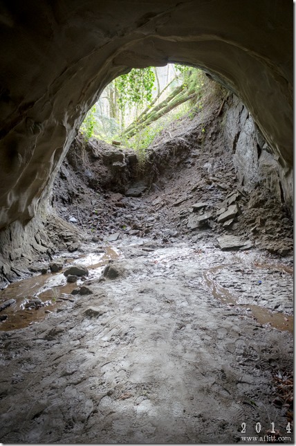
Westport Tunnel - Westbound (2014)

Backfilled West Entrance - Westport Tunnel - Westbound (2014)
Westport, Oregon. March 15, 2014
Copyright © 2014 A. F. Litt, All Rights Reserved

So this is an interesting place that I have never heard about anywhere before, except for the Waymarking.com mention below…  We were planning a trip out to the lower highway, and I was preparing by searching for interesting places we might overlook if we didn’t know they were there when I found the page link below.

This is all I know about this site.

From Waymarking.com:

The Westport tunnel is one of the oldest surviving railroad tunnels in the Pacific Northwest. It was constructed around the 1880s. First used by oxen to move logs from the forest, through this tunnel and to the Columbia River over a skid road south to a logging camp.

In 1907, ox teams were replaced by steam locomotives. The tunnel which was built just large enough for ox teams was significantly widened and deepened to accommodate a locomotive.

In 1915 the railroad tunnel was apparently abandoned and the tracks pulled up.

Highway 30, then a dirt road, was completed through Westport at the time the tunnel and railroad were abandoned. Highway construction obliterated much of the grade north of the tunnel and required that the tunnel be partly backfilled to prevent West Creek from washing away the highway during flood seasons. The part of Highway 30 in front of the tunnel was later bypassed and other than broken pavement of the two lane road, the scene in front of the tunnel looks almost as it did when the tunnel was abandoned in 1915.

In December 2007, a major storm swelled up West Creek, which then overflowed into the tunnel and changed the back and floor of the tunnel.


http://www.waymarking.com/waymarks/WM8NAX_1880s_Westport_Tunnel

Original Columbia River Highway Fragment (2014)
Westport, Oregon. March 15, 2014
Copyright © 2014 A. F. Litt, All Rights Reserved


CRH Bridge Long Gone at West Creek (2014)
Westport, Oregon. March 15, 2014
Copyright © 2014 A. F. Litt, All Rights Reserved


Westport Tunnel Road - Eastbound from Dead End (2014)
Westport, Oregon. March 15, 2014
Copyright © 2014 A. F. Litt, All Rights Reserved


Westport Tunnel Road CRH Fragment - Westbound to Washout (2014)
Westport, Oregon. March 15, 2014
Copyright © 2014 A. F. Litt, All Rights Reserved


Old Barn Across West Creek (2014)
Westport, Oregon. March 15, 2014
Copyright © 2014 A. F. Litt, All Rights Reserved


Waymark for the Westport Tunnel
http://www.waymarking.com/waymarks/WM8NAX_1880s_Westport_Tunnel


Approach to Westport Tunnel
Westport, Oregon. March 15, 2014
Copyright © 2014 A. F. Litt, All Rights Reserved

Westport Tunnel (2014)
Westport, Oregon. March 15, 2014
Copyright © 2014 A. F. Litt, All Rights Reserved

Westport Tunnel - Eastbound (2014)
Westport, Oregon. March 15, 2014
Copyright © 2014 A. F. Litt, All Rights Reserved

Westport Tunnel - West Entrance (2014)
Westport, Oregon. March 15, 2014
Copyright © 2014 A. F. Litt, All Rights Reserved

Old CRH - Westport Tunnel Road
Westport, Oregon. March 15, 2014
Copyright © 2014 A. F. Litt, All Rights Reserved


Intersection of Old and New Columbia River Highways (2014)
Westport, Oregon. March 15, 2014
Copyright © 2014 A. F. Litt, All Rights Reserved

CRH Fragment - Westport Tunnel Road
Westport, Oregon. March 15, 2014
Copyright © 2014 A. F. Litt, All Rights Reserved

On the wesbite:
Tuesday, September 2, 2014

The Start, or the End, of the Road

Before the Ocean
Seaside, Oregon. February 22, 2014
Copyright © 2014 A. F. Litt , All Rights Reserved

The Beginning (2013)
Pacific Ocean from the western terminus of the Columbia River Highway. Seaside, Oregon. March 27, 2013.
Copyright © 2014 A. F. Litt, All Rights Reserved

Originally I based my "start" of the Columbia River Highway in Seaside on Clarence Mershon's use of the Lewis and Clark roundabout as the western terminus of the highway.  However, as I've read through the old Oregon State Highway Commission documents, I am starting to feel that this is more of a romantic choice than a technically accurate choice.

I am beginning to believe that the route from Astoria to Seaside was never actually intended to be the "end" of the CRH (Route 2), but rather the beginning of the Coast Highway (Route 3).

However, for a very short period, this section of roadway may have been considered to be a part of the CRH, if not in official designation, at least in spirit...  Regardless of the OHC’s designation, Samuel Lancaster himself, in his 1915 book, seems to indicate that the highway ends in Seaside, so it is really a tough call to make.

Seaside - The End Of The Lewis And Clark Trail
Samuel C. Lancaster. The Columbia: America's Great Highway. Atglen, PA: Schiffer Publishing, Ltd. 1915. Reprinted 2004.

Seaside "Turn-Around"
Clarence E. Mershon. The Columbia River Highway: From the Sea to the Wheat Fields of Eastern Oregon. Portland: Guardian Peaks Enterprises. 2006. 1st Edition. (5)


Soon after its founding, the Oregon Highway Commission decided to extend the Columbia River Highway (CRH) westward to Seaside. On November 4, 1913, Clatsop County voters approved a bond issue for $400,000 for highway construction. By April 1914, forty-six miles of roadway, much of it through standing timber, had been surveyed. As planned, Seaside became the western terminus of the CRH. From Seaside, the highway paralleled the ocean beaches for twelve miles, then cut across lowlands another twelve miles into Astoria.


Clarence E. Mershon.  The Columbia River Highway: From the Sea to the Wheat Fields of Eastern Oregon. Portland: Guardian Peaks Enterprises.  2006. 1st Edition.  (7)


Turn-around at Seaside, Oregon, ca. 1937
Turn-around at Seaside, a resort town on the North Oregon Coast in Clatsop County. People sit in the sunshine on park benches lining the sidewalk of the turn-around. The Pacific Ocean is in the background.
Photographer: Ralph Gifford
Oregon State Archives, Oregon Department of Transportation, OHDG215
http://photos.salemhistory.net/cdm/singleitem/collection/orarc/id/2

Seaside "Turn-Around" (2014)
The western terminus of the Columbia River Highway.
Seaside, Oregon. February 22, 2014
Copyright © 2014 A. F. Litt , All Rights Reserved

Original Western Terminus of the Columbia River Highway
Google Earth, 2012 Image

Originally considered the western terminus of the Columbia River Highway, the "turn-around" at Seaside lost that status when the State Highway Commission proposed a 430-mile highway from Astoria to the California state line. Seaside, given "End-of-the-Trail" recognition by historians because of the salt cairn established there by the Lewis and Clark Expedition, was a logical choice as the western terminus of the great highway that followed in the "footsteps of Lewis and Clark" from Umatilla to the Oregon Coast.

Clarence E. Mershon.  The Columbia River Highway: From the Sea to the Wheat Fields of Eastern Oregon. Portland: Guardian Peaks Enterprises.  2006. 1st Edition.  (5)

Seaside Roundabout and Promenade (2014)
Columbia River Highway Terminus. Seaside, Oregon. February 22, 2014
Copyright © 2014 A. F. Litt , All Rights Reserved

Monument and Highway (2014)
Seaside, Oregon. February 22, 2014
Copyright © 2014 A. F. Litt , All Rights Reserved

Still Looking West (2014)
Lewis and Clark "End of the Trail" Monument. Western Terminus, HCRH.
Seaside, Oregon. February 22, 2014
Copyright © 2014 A. F. Litt , All Rights Reserved

End of the Trail Base (2014)
Seaside, Oregon. February 22, 2014
Copyright © 2014 A. F. Litt , All Rights Reserved

Promenade Dedication Plaque
Seaside, Oregon. February 22, 2014
Copyright © 2014 A. F. Litt , All Rights Reserved

Start of the Columbia River Highway (2014)
Broadway St. Seaside, Oregon. February 22, 2014.
Copyright © 2014 A. F. Litt , All Rights Reserved

Oregon State Highway Commission - 4th Biennial Report of the Oregon State Highway Commission Covering the Period December 1st, 1918 to November 30th, 1920
http://digital.lib.pdx.edu/oscdl/files/odot/pdx005t0003.pdf

Oregon State Highway Commission - 4th Biennial Report of the Oregon State Highway Commission Covering the Period December 1st, 1918 to November 30th, 1920
http://digital.lib.pdx.edu/oscdl/files/odot/pdx005t0003.pdf