High winds slam East County, Columbia Gorge | kgw.com Portland: "KGW Meteorologist Nick Allard said Thursday that he expected a windy day ahead with gusts up to 80 mph at Crown Point."
Slight Breeze from the East | Columbia River GORGEOUS: "Well, it is a little breezy here in the Gorge this week. Trees are falling over, limbs are ripping through the air, litter is playing tag, rangers are trapped in their vehicles at Vista House, visitors are finding (and losing) their center of gravity, and newscasters are having a heyday."
Sunday, January 26, 2014
Wednesday, January 15, 2014
The Original HCRH Route Between Cascade Locks and Wyeth
While the 2006 HCRH Master Plan appears to be correct in that there is only one known existing fragment of the HCRH river route between Herman Creek / Wyeth Road and Wyeth, there is an earlier route, closely following the Herman Creek / Wyeth Road, that seems to be mostly entirely intact. It is, in fact, the original route of the Wyeth Road itself.
Considering that the steepness of the existing pavement on the Wyeth Road is a concern of the State Trail Planners, I wonder why they are not already planning on using this route for the trail. It is less steep, more curvy, and the right size (of course) for a bike path.
1914 - Built - Grading of three segments in Hood River County totaling 5.3 miles. (Multnomah / Hood River County line to 1/2 mile west of Cascade Locks - 1.5 miles; east of Wyeth to Shellrock Mountain - 1.7 miles; and Shellrock Mountain to Viento - 2.1 miles.)
I suspect that this work was done in order to connect existing sections of road, as the bridge (the Shellrock Mountain Road) between the Wyeth to Shellrock and the Shellrock to Viento segment was already complete at this time.
1912 - Built - Simon Benson contributed $10,000 for the construction of a new road across Shellrock Mountain. The road was built by Honor prisoners from the State Penitentiary.
So, it follows that the 1914 grading of 1.7 miles between Wyeth and Shellrock was connecting Shellrock to the existing Herman Creek / Wyeth road coming out of Cascade Locks, and this is the route reflected in the earlier 1913 / 1916 USGS map.

Detail - HCRH Herman Creek to Shellrock - Mt. Hood - Edition of March 1913, Reprinted 1916
Later on, the actual HCRH was then built following its own, new route above the river and railway.
1914-1915 - Built - 22 miles were graded from 2 1/2 miles west of Cascade Locks to the city of Hood River.

Detail - HCRH Herman Creek to Lindsey Creek - Hood River - 1926
This seems to clarify some confusion. In October 2013, I spoke with a fellow out on an old road grade in this section who told me that the old highway route was over the Wyeth Bench, following the Herman Creek / Wyeth Road. He had worked in many roles in the area over the last 45 years, and spoke of old maps referring to an unpaved road on the south side of the west Wyeth Road slope as being the original highway. Walking this route (pictures below), there were no artifacts that would indicate that it was ever a part of the HCRH, while all of the maps and photos I had seen to this point indicated a river route to the north.
However, for a short period, this route was surely, considering the maps and construction dates, the original route of the HCRH.
At this point, I am uncertain of this road's origins, but I suspect that it might actually have been the 1872 Wagon Road. If so, this might be the best preserved segment of this route left in the gorge, as it is still driveable and showed signs of recent use (tire tracks).
HCRH - Wyeth Road Route:
The old road, south of the current road, is less steep than the new road, but it does have a lot of twisty curves and a steep drop to the north. Comparing the Google Earth imagery with the maps above, it is clear that the Wyeth Road route was changed at some point.
Also, this might be the definitive answer to my power line question. Here, clearly, the road moved and the power lines stayed behind.

Wyeth Road. The old route, matching the old maps, is visible.
Google Earth. Imagery Date: July 18, 2010
Google Earth. Imagery Date: July 18, 2010

Wyeth Road. The old route (straight line) and the new (large curve).
Google Earth. Imagery Date: July 18, 2010
Google Earth. Imagery Date: July 18, 2010

Historic Columbia River Highway. Columbia River Gorge National Scenic Area. Oregon. October 11, 2013.
Copyright © 2014 A. F. Litt, All Rights Reserved
Tuesday, January 14, 2014
Warren Falls / Hole In the Wall Falls: Collected WyEast Blog Posts by Tom Kloster
 |
| Resting at Hole in the Wall Falls Starvation Creek State Park. Columbia River Gorge National Scenic Area. Oregon. April 26, 2013. A. F. Litt 2013 |
Restoring Warren Creek Falls | WyEast Blog: "Until the 1930s, Warren Creek was much like it’s neighbors to the east and west in the Columbia River Gorge, plunging in a spectacular waterfall as it reached the final wall of cliffs lining the river. For millennia, the stream had slowly carved a huge amphitheater in sheer basalt, thundering into a deep splash pool at the base of the cliffs, before rushing to the Columbia.
The railroads crossed Warren Creek in the late 1800s, and by the 1920s, Samuel Lancaster’s iconic Historic Columbia River Highway had been constructed, and passed the stream near the falls. Sometime in the late 1930s, the Oregon Highway Department determined that Warren Creek posed a risk to the highway grade, and made the improbable decision to re-route the falls through a tunnel, depositing the stream a few hundred yards to the west."

Starvation Creek Loop Hike | WyEast Blog: "After taking in the scene at the former Warren Falls, retrace your steps on the boot path to the footbridge and turn right, continuing along the main trail for your return to the trailhead (note: the restored Historic Columbia River Highway and trail will soon be constructed in this area, with a new trailhead for the Starvation Ridge Trail relocated to this spot). The route briefly passes an open area, and then re-enters forest. Watch for old, stone foundations covered in ivy in this area — you’re passing turn-of-the-century homesteads lost to time. Sharp-eyed hikers will also spot a pair of enormous anthills, each measuring six feet in height. A bit further, and you’ll also pass dome-shaped stone bake ovens, possibly built in the early 1900s by highway workers (see the map below for help in finding these traces of human history in the Warren Falls area)."
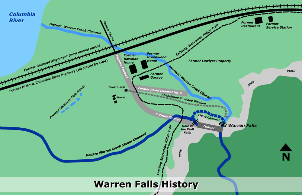 |
| Map of Warren Falls History by Tom Kloster http://wyeastblog.org/ |
Warren Falls Mystery… Solved! | WyEast Blog: "It was the summer of 1939, and Depression-era Americans were escaping the hard times with the theater releases of “Gone with the Wind” and “The Wizard of Oz”. In Europe, Hitler’s invasion of Poland in September of 1939 ignited World War II.
Against the sweeping backdrop of this pivotal year in history, a odd story was playing out on obscure Warren Creek, near Hood River in the Columbia River Gorge. This is the story of how today’s manmade Hole-in-the-Wall Falls was created, and Warren Falls was (temporarily, at least) lost to time. "
 |
| "Historic site map of the Warren Falls diversion project (1939)" Source: WyEast Blog. Tom Kloster. http://wyeastblog.org/ |
Warren Falls Solutions | WyEast Blog: "The strange history of Warren Falls began shortly after completion of the Historic Columbia River Highway in the 1920s, when unruly Warren Creek repeatedly pushed debris against the modest new highway bridge that spanned the stream.
The first Warren Creek bridge was replaced as part of the waterfall diversion; no photos of the original structure survive.

Oregon highway engineers subsequently diverted the creek in 1939 through a bizarre tunnel that survives to this day. The diversion created today’s manmade Hole-in-the-Wall Falls when an accompanying flume was removed sometime in the early 1960s, leaving an eerie, dry cliff where Warren Falls once thundered.
This article proposes a few solutions for restoring Warren Falls to its former glory in tandem with the ongoing ODOT project to restore the Historic Columbia River Highway."
 |
| The 1939 construction drawings for the diversion project show the v-shaped vault carved into the lip of Warren Falls, leading to the diversion tunnel (cross-section view) http://wyeastblog.org/2012/02/27/warren-falls-solutions/ |
Warren “Barney” Cooper | WyEast Blog: "While tracking down the human history behind the mysterious (and temporarily defunct) falls on Warren Creek in the Columbia River Gorge over the past year, I was surprised to learn that “Warren” is not the surname of a local homesteader or early explorer.
Instead, it is the first name of an early Forest Service ranger, Warren “Barney” Cooper, whose own surname puts him among Mount Hood’s pioneering royalty: the remarkable Coopers of the Hood River Valley."
Warren Falls Lives! (temporarily, at least) | WyEast Blog: "It was remarkable to be in the amphitheater with water cascading over the escarpment, once again, and even if only temporarily. The small amount making its way over the brink completely changed the place from an eerie, somber cavern to a bright, sparkling glen. It was even more exciting to imagine the full force of Warren Creek plunging over the high cliffs, given the thundering display at Hole-in-the-Wall Falls (which is created by the bypass tunnel)."
Warren Falls Lives… Again? | WyEast Blog: "March 16 was a good day for Warren Falls: in the morning, the Historic Columbia River Highway Advisory Committee (AC) allowed me time on their agenda for a second pitch to restore Warren Falls as part of the larger historic highway trail project. After the meeting, I visited Warren Falls and was able to capture it flowing, thanks to the unusually heavy rain we had experienced in early March. Here are the highlights:"
“Warren Falls, we’re ready for your close-up…” | WyEast Blog: "This was the second trip to Warren Falls for Oregon Field Guide producer Vince Patton and videographer Michael Bendixen. Both had joined me for a first look at the area on a particularly icy January day last winter when the Gorge was at its worst — freezing rain and sleet over a crusty layer of snow."
Rock as big as Volkswagen falls onto I-84 | kgw.com Portland

Rock as big as Volkswagen falls onto I-84 | kgw.com Portland: "A large rock, described as being the size of a Volkswagen Beetle car, fell onto Interstate 84 about one mile west of Hood River Sunday afternoon."
http://www.kgw.com/news/Rock-as-big-as-Volkswagen-falls-onto-I-84-240016751.html
'via Blog this'
Oregon Field Guide: Warren Falls
"If there’s one thing that makes the Columbia River Gorge stand out, it’s the waterfalls. But did you know that one of those waterfalls is not natural. One waterfall lover wants that man-made waterfall closed down in order to restore Warren Falls, which has been blocked for more than 70 years."
Aired: 10/25/2012 - 7:57
“Warren Falls, we’re ready for your close-up…” | WyEast Blog: "This was the second trip to Warren Falls for Oregon Field Guide producer Vince Patton and videographer Michael Bendixen. Both had joined me for a first look at the area on a particularly icy January day last winter when the Gorge was at its worst — freezing rain and sleet over a crusty layer of snow."
“Warren Falls, we’re ready for your close-up…” | WyEast Blog: "This was the second trip to Warren Falls for Oregon Field Guide producer Vince Patton and videographer Michael Bendixen. Both had joined me for a first look at the area on a particularly icy January day last winter when the Gorge was at its worst — freezing rain and sleet over a crusty layer of snow."
Monday, January 13, 2014
When the HCRH & I-84 First Meet: Puzzling Out the Original HCRH Alignment Through Dodson & Warrendale
Excerpted from:

UPDATE: September 6, 2014
After looking at this for over a year now, tearing my hair out, and just jumping up and down being mad, I am, for the most part, now willing to accept that the Frontage Road is the original Route 2 alignment.
However, I still want to know what is going on with the over-engineered parts of Enquist and Warrendale Roads!
The HCRH Meets The Interstate
Historic Columbia River Highway. Columbia River Gorge National Scenic Area. Oregon. April 23, 2013
Historic Columbia River Highway. Columbia River Gorge National Scenic Area. Oregon. April 23, 2013
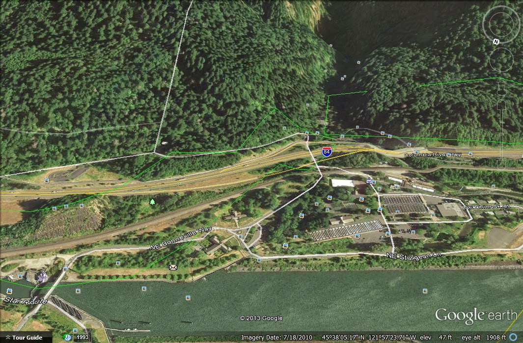
In the photo below, from left to right, north to south, are Tumalt Road, Warrendale Road, I-84, NE Frontage Road, and a mysterious winding track through the woods. But which, if any, is the original historic highway?

Tumalt Road, Warrendale Road, I-84, NE Frontage Road, and a mysterious winding track through the woods.
Google Earth. Imagery Date: July 18, 2010
Thursday, January 9, 2014
Benson Bridge Damaged by Rockfall
From the U.S. Forest Service:
Benson Bridge Closure Date(s): Jan 9, 2014 Starting immediately, Benson arch bridge on Larch Mountain trail #441 at the base of Multnomah Falls is closed due to severe damage from a fallen rock. Engineers are working on an inspection. Larch Mountain trail #441 will be closed from Multnomah Falls viewing plaza near Multnomah Falls Lodge to the Gorge #400 trail until further notice.
http://www.fs.usda.gov/alerts/crgnsa/alerts-notices/?aid=21246
From KGW:
This isn't the first time a large rock has fallen on the Benson Bridge, but it has been quite a while.
In 1995, a boulder the size of a school bus slid from the face of upper Multnomah Falls and dropped into the upper plunge pool. This created a splash of 70 feet and sent rocks flying over the bridge.
A large wedding party just happened to be on the bridge for photos when the boulder fell and 20 people were injured by rock shrapnel, including the groom. No one had serious injuries though, and the bride and groom's story was featured the next day in the newspaper.
http://www.kgw.com/news/Large-rock-falls-on-iconic-bridge-at-Multnomah-Falls-239483641.html
Monday, January 6, 2014
Lindsey Creek & Lindsey Pond

Lindsey Lake and the Gorge East From HCRH State Trail Route (2013)
Lindsey Creek State Park. Columbia River Gorge National Scenic. Oregon. November 1, 2013.
Lindsey Creek State Park. Columbia River Gorge National Scenic. Oregon. November 1, 2013.
From:
Lindsey Creek was named for John Lindsey, an early homesteader. The creek heads at North Lake and flows northeast into the Columbia River at Lindsey Pond, 2.5 miles north of Mount Defiance. The mouth is located at Columbia River Mile (RM) 159. Lindsey Pond is separated from the Columbia by a levee for the Union Pacific Railroad tracks. Upstream of Lindsey Creek is Wonder Creek and Starvation Creek and State Park and downstream is Summit Creek and Shellrock Mountain. The U.S. Board of Geographic Names made "Lindsey Creek" the official name in 1995. In the 1930s the Union Pacific Railroad had a station named Lindsey.
The original Lindsey Pond is seen in the foreground of the photo below, though the whole architecture of the river through here has changed since this photo was shot, and the old, apparently somewhat natural pond is, really, no more, just a small man-made lagoon created by the railroad tracks.Lyn Topinka. The Columbia River: A Photographic Journey.

Columbia Gorge Discovery Center Photo Archive
Catalog Num: 2000.16.10
Condition: Good
Date:
Location: Columbia River Highway, Oregon
Title:
Content: Wind Mountain and sunset skies
Other Notes:
Photographer: Eddy
Copyright: Eddy
http://www.gorgediscovery.org/photoarchive/newDetails.asp?offset=780&ID=2428
Catalog Num: 2000.16.10
Condition: Good
Date:
Location: Columbia River Highway, Oregon
Title:
Content: Wind Mountain and sunset skies
Other Notes:
Photographer: Eddy
Copyright: Eddy
http://www.gorgediscovery.org/photoarchive/newDetails.asp?offset=780&ID=2428

CRH between Shellrock Mountain and Starvation Creek
Clarence E. Mershon. The Columbia River Highway: From the Sea to the Wheat Fields of Eastern Oregon. Portland: Guardian Peaks Enterprises. 2006. 1st Edition. 186
Clarence E. Mershon. The Columbia River Highway: From the Sea to the Wheat Fields of Eastern Oregon. Portland: Guardian Peaks Enterprises. 2006. 1st Edition. 186
Looks like the old lake's level was pretty variable. More of a slough than a lake, really.

All of the land visible on this map north of the train tracks and highway is now gone. However, it is still there in the photo above. Lindsey Pond is also, essentially, gone.


"Baldock’s faster, straighter version of the Columbia River Highway began to emerge in the 1940s"
Tom Kloster. WyEast Blog: Warren Falls Mystery… Solved! http://wyeastblog.org/2012/01/31/warren-falls-mystery-solved/
Sunday, January 5, 2014
The Western Terminus of the Columbia River Highway
From:
(http://www.recreatingthehistoriccolumbiariverhighway.org/HCRH-Segments/west-of-portland-1)
Seaside, Oregon:

The Beginning (2013)
Pacific Ocean from the western terminus of the Columbia River Highway. Seaside, Oregon. March 27, 2013. Copyright © 2014 A. F. Litt, All Rights Reserved
The photo above was taken from the roundabout at the end of the Columbia River Highway, pictured below. At the time I was there, I was not working on this project yet and I did not know the historical significance of the location. We just happened to park nearby and to wander past it on our way to take a look at the ocean. So, instead of shooting the historical landmark, I went for a swing-set and clouds instead, and this is the only photo that I have, to date, from this location.
I hope to make it out there again before the end of this project, but since this section is not my primary focus, it will only be if time allows sometime between now and 2016. (January 5, 2014)

Clarence E. Mershon. The Columbia River Highway: From the Sea to the Wheat Fields of Eastern Oregon. Portland: Guardian Peaks Enterprises. 2006. 1st Edition. (5)

Google Earth, 2012 Image
Originally considered the western terminus of the Columbia River Highway, the "turn-around" at Seaside lost that status when the State Highway Commission proposed a 430-mile highway from Astoria to the California state line. Seaside, given "End-of-the-Trail" recognition by historians because of the salt cairn established there by the Lewis and Clark Expedition, was a logical choice as the western terminus of the great highway that followed in the "footsteps of Lewis and Clark" from Umatilla to the Oregon Coast.
Clarence E. Mershon. The Columbia River Highway: From the Sea to the Wheat Fields of Eastern Oregon. Portland: Guardian Peaks Enterprises. 2006. 1st Edition. (5)
Saturday, January 4, 2014
View Point Inn: Basic History
From:
(http://www.recreatingthehistoriccolumbiariverhighway.org/HCRH-Segments/007---chanticleer-point-to-crown-point)
First opened in 1924 or 1925, then closed in 1962, then opened, briefly in 1997 before being closed again... When it finally reopened, in 2006, I think, it quickly showed up in the 2008 movie Twilight before closing due to fire damage in 2011.
I'll try not to draw a connection, since I know a few people like that film and I don't want to see them put off by a comment about karma...
The most recent owner, Geoff Thompson, started repairing the Inn in 2013.


Another article on the fire, with photos...


(http://www.recreatingthehistoriccolumbiariverhighway.org/HCRH-Segments/007---chanticleer-point-to-crown-point)
View Point Inn:
I'll try not to draw a connection, since I know a few people like that film and I don't want to see them put off by a comment about karma...
The most recent owner, Geoff Thompson, started repairing the Inn in 2013.
The original property was owned by Lorens Lund, a Danish immigrant who came to the United States in the 1870’s. Lund and Norwegian wife, Mari, gave the name “Thor’s Heights” to their 120 acres overlooking Crown Point in the Columbia River Gorge. The land was later purchased by the Grace H. Palmer Corporation. Mrs. Palmer hired highly renowned Portland architect, Carl Linde, to design and build a $47,000 Tudor Arts and Crafts Style “tea house” and “resort”. The Palmer House, as it came to be called, opened on June 4, 1925, in hopes of capturing the growing market of automobile tourism that was growing in the Gorge area thanks to the Columbia River Highway.
Mrs. Palmer’s hopes were dashed however in 1927, as bankruptcy forced the Grace H. Palmer Corporation to liquidate and sell the Palmer House. Luckily, William Moessner, the prestigious German chef de cuisine of downtown Portland’s Benson Hotel purchased the property and renamed it The View Point Hotel. He ran a highly successful business with his wife Clara for over 50 years. It was during this time that numerous Hollywood celebrities, famous Americans, and European royals frequented the Inn, including such notables as President Franklin D. Roosevelt and Charlie Chaplin. The View Point Hotel remained highly successful until the 1960’s.
From View Point Inn: http://www.theviewpointinn.com/inn/history.html
The Inn became a regular stop for charter buses bringing visitors to the Gorge for a salmon dinner.
Clarence E. Mershon. East of the Sandy: The Columbia River Highway. Portland: Guardian Peaks, Inc. 2001. 1st Edition. (37)
After the opening of Interstate 84, automobile tourism along the Columbia River Highway faded away, as did the many inns and restaurants dotting the scenic drive. Proprietor William Moessner, however, stubbornly refused to accept defeat. Every day, he kept the inn immaculate and ready for business. While there is much speculation, no one really knows when the last meal was served. However, we do know that Moessner faithfully tended to the ghost hotel up until the day of his death in 1979.
From View Point Inn: http://www.theviewpointinn.com/inn/history.html
Moessner closed the Inn in 1962, but continued to live on the premises until his death in 1979.
Clarence E. Mershon. East of the Sandy: The Columbia River Highway. Portland: Guardian Peaks, Inc. 2001. 1st Edition. (37)
The inn was subsequently purchased in 1982 by Doug and Karen Watson, who helped to win it a spot on the National Register of Historic Places in 1985. Only four properties boast this prestigious distinction in the entire Columbia River National Scenic Area.
From View Point Inn: http://www.theviewpointinn.com/inn/history.html
The Inn is listed in the National Register of Historic Places. When an inventory of historic buildings was completed for the proposed Columbia River Gorge National Scenic Area, the Inn was closed, hence was not included as a commercial enterprise. Therefore we have an incongruity - an Inn with a recognized historic importance that cannot now operate as an Inn. This is unfortunate, not only because of the historic significance of the building, but because it should be open for use by the public. [Its restrooms would be a welcome addition for visitors, particularly the elderly or disabled.]
Clarence E. Mershon. East of the Sandy: The Columbia River Highway. Portland: Guardian Peaks, Inc. 2001. 1st Edition. (37)
The Inn’ current owner, Geoff Thompson, secured the property in 1997 and started a very successful restaurant and bed & breakfast. In 1998 the U.S. Forest Service purchased the land surrounding the property and wanted to link the inn with the nearby Vista House to create a state park. Government agencies colluded together and drove Thompson off his land in 1999.
From View Point Inn: http://www.theviewpointinn.com/inn/history.html
Recently, after re-opening in 1997 under a very restrictive permit issued by Multnomah County, the new owners found themselves involved in a court case engendered by a complaint about its operation and parking. The court found that the owners of the Inn had violated their operating permit. An appeal to the Gorge Commission failed for the reason cited above. Apparently, an Act of Congress would be required to allow the Inn to operate as an Inn. Hence, the View Point Inn joins the list of historic structures that have not fared well under the Scenic Area Act, despite its provisions related to historic preservation.
Clarence E. Mershon. East of the Sandy: The Columbia River Highway. Portland: Guardian Peaks, Inc. 2001. 1st Edition. (37 - 38)
Due to his great love of the gorgeous historic property, Thompson fought to legally block the sale of the inn and the ghost hotel sat empty for the next four years. In 2003, he returned and purchased the inn a second time with his partner Angelo Simione. After a three year legal battle, which included amending a Federal Act, Thompson finally emerged victorious! That December, The View Point Inn became an Oregon landmark once again.
From View Point Inn: http://www.theviewpointinn.com/inn/history.html
Before the fire... View Point Inn from Portland Women's Forum Viewpoint, Corbett, Oregon. February 22, 2011.
The historic 1296 Inn is nowadays famed for its part in the hit vampire movie Twilight. Fans come from around the world to see the prom scene "Hotel Monte Carlo" and maybe go on the "Twilight Sights" bus tour hosted by the Inn. The Inn has quaint rooms and a breakfast/lunch/dinner dining room just dripping with old-time charm and elegance.
Scott Cook. Curious Gorge: Over 100 Hikes and Explorations in the Columbia River Gorge. Hood River, OR: Scott Cook. 2010. 3rd Edition. (19)
View Point Inn & burned roof from Women's Forum Viewpoint. Columbia River National Scenic Area. Oregon. October 16, 2012
The historic View Point Inn and Restaurant in Corbett lost most of its roof in a fire Sunday, and blackened debris covered the furniture and floor on the hotel's second floor. But the owners of the hotel, which overlooks the Columbia River Gorge, are still not sure how they will pay for repairs.
The building has not been insured since April, said Geoff Thompson, who owns the inn with his partner Angelo Simione.
Sophia Li, The Oregonian "View Point Inn in Corbett was uninsured, say owners after Sunday's fire" The Oregonian July 11, 2011 at 8:57 PM, updated July 13, 2011 at 7:28 PMhttp://www.oregonlive.com/pacific-northwest-news/index.ssf/2011/07/corbetts_view_point_inn_was_uninsured_say_owners_after_sundays_fire.html
September 28, 2011, Willamette Week Cover Story:
LARGER THAN LIFE: Thompson's crucifixion picture.
IMAGE: Willamette Week / James Rexroad
IMAGE: Willamette Week / James Rexroad
Like rubberneckers at a car crash, gawkers flock to the Viewpoint Inn.
Some inch close to the cliff at the edge of the property and gaze at the Columbia River, 1,100 feet below.Twilight groupies make the pilgrimage to see where pivotal scenes from the 2008 cult vampire flick were shot.
Others come to inspect the damage from a July fire that left the 87-year-old inn a charred ruin.
And everybody who visits the Viewpoint now witnesses something else: a larger-than-life photo of inn owner Geoff Thompson, his bodybuilder’s physique naked except for a strategically placed banner.
Above Thompson’s head on the photo are the words “Small Business Crucified,” and across his midsection, the banner reads, “By the Obama Administration.”
The Christ metaphor suits Thompson’s worldview.
“It’s been rough here,” Thompson says. “But what I’ve gone through has made me an amazing human being.”
The crucifixion image is unsettling to neighbors in the unincorporated east Multnomah County hamlet of Corbett.
Nigel Jaquiss. "The Crucifixion of Geoff Thompson" Willamette Week. September 28th, 2011 http://www.wweek.com/portland/article-18016-the_crucifixion_of_geoff_thompson.html
View Point Inn and Larch Mountain from Chanticleer Point
Columbia River Gorge National Scenic Area. Oregon. April 23, 2013.
Columbia River Gorge National Scenic Area. Oregon. April 23, 2013.
Despite the obstacles and fleeting hope, Geoff Thompson is finally taking the initial steps toward restoring the View Point Inn, a historic building in Corbett that was ravaged by fire in July 2011....Money from an insurance settlement will fund the project, which, Thompson said, will be complete in spring 2014.He added that the structure will need a new roof, and there is significant interior damage. Reconstructing the building’s shell should be complete by Labor Day, and then the focus will move to the interior next winter.
Kristopher Anderson. "Construction begins at View Point Inn" Portland Tribune. January 18, 2013 http://portlandtribune.com/go/42-news/126748-construction-begins-at-view-point-inn
1920 Brochure - Forest trails and highways of the Mount Hood Region
Originally posted on Rubble on October 10, 2013:
http://rubble.blogspot.com/2013/10/1920-brochure-forest-trails-and.html
Forest trails and highways of the Mount Hood re...: 'via Blog this'


http://rubble.blogspot.com/2013/10/1920-brochure-forest-trails-and.html
Forest trails and highways of the Mount Hood re...: 'via Blog this'
Lancaster's Lodge and Retirement Cabin at Tanner Creek (UPDATED: March 20, 2014)
Originally posted on Rubble on September 20, 2013:
http://rubble.blogspot.com/2013/09/lancasters-logde-and-retirement-cabin.html
Several of us were discussing Lancaster's retirement during the weekend of the Yeon to Moffett Creek HCRH Trail Dedication... Apparently, I was combining two different stories. I was saying that Lancaster retired on Bell's property, but these were two different locations.
"Samuel Lancaster built a private 72-acre campground at Bonneville that overlooked Bradford Island and the lower Cascade rapids. He constructed a log dining hall and tent 'cabins' at camping areas. Lancaster used facilities he had observed in Switzerland as a model for his development. The log structure burned in the late 1920s and was not replaced. In 1928, Sam Hill built a 22-room house on a 35-acre estate at Bonneville for his 'friend' Mona Bell. Because the property was required for the construction of Bonneville Dam, the government purchased the estate in 1934." - Clarence E. Mershon, The Columbia River Highway: From the Sea to the Wheat Fields of Eastern Oregon
"...while across the road Lancaster established a campground and recreational facility, Camp Get-A-Way." - Clarence E. Mershon, East of the Sandy: The Columbia River Highway
"In the 20s, Sam Hill built a large home on top of the large rock formation north of I-84, east of exit 40. The house was razed in the late 50s." - Clarence E. Mershon, East of the Sandy: The Columbia River Highway
.jpg)
.jpg)
.jpg)
.jpg)
.jpg)
Additional photos from Scott Cook / Curious Gorge:
The long-gone Mona Bell mansion built by Sam Hill for his mistress Mona Bell:
http://www.panoramio.com/photo/52098770
Mona Bell's one-time mansion atop Bonneville Rock:
http://www.panoramio.com/photo/74053683
Remnant foundation of Mona Bell Hill's mansion:
http://www.panoramio.com/photo/74053689

Bell's mansion was on the hill on the east end of the screenshot above, between I-84 and the railroad tracks. The relocation of the rail line to its current route when its former path was flooded by the dam apparently blasted away a large chunk of Mona's hill, and the construction of I-84 apparently took out another large chunk of it, leaving only a sliver of the land that once held her mansion and, consequently, only a small sliver remains of Bonneville State Park.
UPDATE: March 10, 2014
http://rubble.blogspot.com/2013/09/lancasters-logde-and-retirement-cabin.html
Several of us were discussing Lancaster's retirement during the weekend of the Yeon to Moffett Creek HCRH Trail Dedication... Apparently, I was combining two different stories. I was saying that Lancaster retired on Bell's property, but these were two different locations.
"Samuel Lancaster built a private 72-acre campground at Bonneville that overlooked Bradford Island and the lower Cascade rapids. He constructed a log dining hall and tent 'cabins' at camping areas. Lancaster used facilities he had observed in Switzerland as a model for his development. The log structure burned in the late 1920s and was not replaced. In 1928, Sam Hill built a 22-room house on a 35-acre estate at Bonneville for his 'friend' Mona Bell. Because the property was required for the construction of Bonneville Dam, the government purchased the estate in 1934." - Clarence E. Mershon, The Columbia River Highway: From the Sea to the Wheat Fields of Eastern Oregon
"...while across the road Lancaster established a campground and recreational facility, Camp Get-A-Way." - Clarence E. Mershon, East of the Sandy: The Columbia River Highway
"In the 20s, Sam Hill built a large home on top of the large rock formation north of I-84, east of exit 40. The house was razed in the late 50s." - Clarence E. Mershon, East of the Sandy: The Columbia River Highway
.jpg)
.jpg)
.jpg)
.jpg)
.jpg)
Additional photos from Scott Cook / Curious Gorge:
The long-gone Mona Bell mansion built by Sam Hill for his mistress Mona Bell:
http://www.panoramio.com/photo/52098770
Mona Bell's one-time mansion atop Bonneville Rock:
http://www.panoramio.com/photo/74053683
Remnant foundation of Mona Bell Hill's mansion:
http://www.panoramio.com/photo/74053689
Bell's mansion was on the hill on the east end of the screenshot above, between I-84 and the railroad tracks. The relocation of the rail line to its current route when its former path was flooded by the dam apparently blasted away a large chunk of Mona's hill, and the construction of I-84 apparently took out another large chunk of it, leaving only a sliver of the land that once held her mansion and, consequently, only a small sliver remains of Bonneville State Park.
UPDATE: March 10, 2014
The Oregonian:
The architectural hash mansion of eccentric Mona Bell Hill was razed for the Bonneville Dam: Historic home series
The architectural hash mansion of eccentric Mona Bell Hill was razed for the Bonneville Dam: Historic home series
First Nations of the Gorge: Columbia Gorge Discovery Center Photo Archive
Originally posted on Rubble on October 15, 2013:
http://rubble.blogspot.com/2013/10/first-nations-of-gorge-columbia-gorge.html
Since I will be taking part in a photo shoot with a Native American theme in the Gorge this weekend, I thought I'd share some historical photos... Columbia Gorge Discovery Center Photo Archive

http://rubble.blogspot.com/2013/10/first-nations-of-gorge-columbia-gorge.html
Since I will be taking part in a photo shoot with a Native American theme in the Gorge this weekend, I thought I'd share some historical photos... Columbia Gorge Discovery Center Photo Archive
Catalog Num: 2002.13.28
Condition: Good
Date:
Location: Celilo Falls
Title:
Content: Indian fishing with dipnet in eddy of the Columbia river.
Other Notes: Used as cover photo for 1987 WCHS calendar. Remarks on back. Duplicate measures same size.
Photographer:
Copyright: Published
Many more photos after the break...
Subscribe to:
Posts (Atom)